RIT archeologist uses satellites to uncover ancient history
A. Sue Weisler | photographer
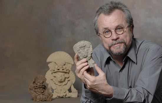
Bill Middleton displays replicas of Zapotec funerary urns. His study will explore the Oaxacan economy and environment in Mexico.
Satellite imagery obtained from NASA will help RIT archeologist Bill Middleton peer into the ancient Mexican past. In a novel archeological application, multi- and hyperspectral data will help build the most accurate and most detailed landscape map that exists of the southern state of Oaxaca, where the Zapotec people formed the first state-level and urban society in Mexico.
“If you ask someone off the street about Mexican archeology, they’ll say Aztec, Maya. Sometimes they’ll also say Inca, which is the wrong continent, but you’ll almost never hear anyone talk about the Zapotecs,” says Middleton, acting chair of the Department of Material Culture Sciences and professor in the Department of Sociology and Anthropology. “They had the first writing system, the first state society, the first cities. And they controlled a fairly large territory at their Zenith—250 B.C. to 750 A.D.”
Middleton’s study will explore how the Oaxacan economy and environment changed as the Zapotec state grew and then collapsed into smaller city-states. Funding from NASA and National Geographic will also help Middleton build a picture of how climate and vegetation patterns have changed over time. Middleton will focus on two sites in the Chichicapam Valley located in between two of the major arms of the central valleys of Zapotec.
The National Geographic-funded portion of the study began last summer when he documented important archeological sites and selected candidates for excavation. Imagery from Earth Observing 1 and Landsat satellites obtained over three years will help Middleton identify the natural resources found at archeological sites. He will work with colleagues John Kerekes and David Messinger along with graduate student Justin Kwon in RIT’s Chester F. Carlson Center for Imaging Science to analyze the large amounts of data taken at different wavelengths of the electromagnetic spectrum—a new approach to analyzing archeological landscapes. Their research uses similar techniques to analyze urban landscapes and inspired Middleton to apply the technology to archeology.
Satellite imagery covering more than 30,000 square kilometers will help Middleton identify different plant species, environments and ecosystems, and acres of arable land or mineral resources surrounding particular sites. The new landscape map will also show how development has changed the region since the last survey conducted 30 years ago. Another aspect of the NASA-funded project will focus on environmental change. This part of the study, done in conjunction with colleagues at the University of Colorado at Boulder will analyze plant microfossils in sediment samples collected from a variety of locations, including areas where streams expose sediment layers 10,000 years old.
Topics
Recommended News
-
April 25, 2024
![a group of staff members in yellow shirts gather under a tent being used as an information booth.]()
Staff volunteers make Imagine RIT shine
RIT staff members volunteer at the festival to assist the university in creating an unforgettable event each year by handing out welcome bags, supervising parking lots, and showing campus visitors around the bustling campus, among other duties. More than 200 staff volunteers annually commit their time to Imagine RIT.
-
April 24, 2024
![David Munson, Jr., RIT President, stands on the second floor balcony of the SHED holding a portrait that shows the renderings before it was built.]()
RIT President David Munson to step down in 2025
Spectrum News features David Munson's retirement plans for 2025, emphasizing his impact on RIT's growth in enrollment, research funding, and global presence. -
April 24, 2024
![A blurry image of a leafy green wooded area]()
Nearsightedness is at epidemic levels – and the problem begins in childhood
The Conversation talks to Andrew Hebert, professor in the Department of Psychology, about the global rise of myopia and its causes, including increased screen time and reduced outdoor exposure.
-
April 24, 2024
![a colorful 3 D image of the southern ring nebula appears in a black sky.]()
See the Southern Ring Nebula in 3D
Universe Today highlights the research led by Joel Kastner, professor in the Chester F. Carlson Center for Imaging Science, on the Southern Ring Nebula's dual-ring formation and the possible role of a second star.