Designing a roadmap for U.S. airspace
Corporate and university partners become part of national plans to improve use of unmanned aircraft systems
A. Sue Weisler
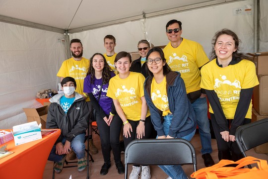
Tim Southerland ’14 (mechanical engineering) launches a quadro-copter, a model drone, controlled by Peter Pietrantoni ’14 (mechanical engineering). Agamemnon Crassidis, an associate professor in the Kate Gleason College of Engineering, watches.
Gale winds shear off roofs during hurricanes. Floods damage homes and properties. Improving the time it takes to assess damage after a natural disaster can be done with unmanned aircraft systems.
Although unmanned aircraft systems are associated with military and law enforcement applications, there’s been a shift in thinking about using them for activities as varied as property assessments, crop surveying, rescue operations and wildlife monitoring, said Agamemnon Crassidis, associate professor of mechanical engineering in RIT’s Kate Gleason College of Engineering.
Crassidis will bring that big-picture vision of the varied uses for unmanned aircraft systems to NUAIR, the Northeast Unmanned Aircraft System Airspace Integration Research Alliance. NUAIR is a group of more than 40 companies and universities in New York and Massachusetts selected in December 2013 as one of six Federal Aviation Administration test sites in the U.S.
The alliance will conduct research to improve current unmanned aircraft technology and recommend safe integration of unmanned aircraft in the national airspace system. Seventeen universities are involved with RIT and Massachusetts Institute of Technology as regional academic leaders.
“One of my key roles is to bring the universities together to see what kinds of research they are doing and how we can use that research,” said Crassidis, who will also serve on NUAIR’s board of directors. He specializes in aircraft control systems and has worked for aerospace companies such as Calspan, an affiliate of the Flight Research Facility in Buffalo, N.Y., specifically part of the team that designed flight simulation systems for jet fighter pilots.
RIT is well positioned for this work with expertise in sensor and aeronautic system development from the Kate Gleason College and in remote sensing and imaging from RIT’s Chester F. Carlson Center for Imaging Science.
“This is a significant opportunity to expand use of remote sensing and imaging and make that imaging accessible to a broader constituency. In some disaster situations, especially with states or counties with tight budgets, access to low-cost imaging is big for them,” said Donald McKeown, distinguished researcher in the Center for Imaging Science.
The team has already received testing and development requests since the December announcement. One of those came from Pictometry and Steve Schultz ’89 (computer science), chief technology officer for the company that focuses on geo-referenced aerial image capture and data analytics.
More than a year ago, Pictometry merged with Eagle View Technologies. The company had been using Pictometry’s imaging systems to generate roof reports.
“It’s very difficult to tell detailed information about roof conditions from traditional aerial views,” said Schultz, an RIT Trustee. “We can fly high enough and get high-resolution images to provide the details, but it is cost prohibitive over a wide area. But doing this with an unmanned aircraft system, over individual homes, if needed, can get a more accurate reading. Underwriters can essentially manage their risk, and using (unmanned aerial vehicles) can help them do that.”
Pictometry plans to contract with RIT for improvements to its obstacle avoidance technology, to create a comprehensive system that would fly over the perimeter of a designated area and capture the images necessary to create a roof model. Upon landing, the system would upload the raw data to the company’s server to generate a roof report for the client, ideally while the client is still onsite. Schultz believes it is a viable goal and the system design and processing capability are being developed.
Using unmanned aircraft could provide multiple benefits not only for companies that can increase assessment activities and keep representatives off unstable roofs or other structures, but also for consumers who rely on insurance adjustments after crises. Improving the time to complete an assessment means better recovery from disasters.
Unmanned aircraft are more than remote-controlled model planes. Today, they consist of complex systems for collision avoidance, automated controls and navigation; they also integrate imaging systems to gather and process data. RIT researchers have already been developing aspects of these technologies and can contribute to improving unmanned aircraft systems.
Regulations currently do not permit unmanned aircraft above 400 feet without certification, and these allowances are given primarily to law enforcement or the military. The FAA has directed new test site teams like NUAIR to contribute recommendations about how corporate and commercial unmanned aircraft can be part of already crowded skies. The Northeast corridor where NUAIR will operate has some of the highest volumes of air traffic to control.
In addition to benefits of new technology and clearer regulations of industry processes, unmanned aircraft systems have the potential to impact the economy, opening up market opportunities, said Crassidis. The need for system components, low-cost sensors, platforms, autonomous control algorithms, sense-and-avoid systems and advanced imaging processing methods offers opportunities for both local companies and universities. According to the Association for Unmanned Vehicle Systems International, UAS may provide 100,000 new jobs in the U.S. and more than $82 billion in economic outcomes by 2025.
Topics
Recommended News
-
April 25, 2024
![a group of staff members in yellow shirts gather under a tent being used as an information booth.]()
Staff volunteers make Imagine RIT shine
RIT staff members volunteer at the festival to assist the university in creating an unforgettable event each year by handing out welcome bags, supervising parking lots, and showing campus visitors around the bustling campus, among other duties. More than 200 staff volunteers annually commit their time to Imagine RIT.
-
April 24, 2024
![David Munson, Jr., RIT President, stands on the second floor balcony of the SHED holding a portrait that shows the renderings before it was built.]()
RIT President David Munson to step down in 2025
Spectrum News features David Munson's retirement plans for 2025, emphasizing his impact on RIT's growth in enrollment, research funding, and global presence. -
April 24, 2024
![A blurry image of a leafy green wooded area]()
Nearsightedness is at epidemic levels – and the problem begins in childhood
The Conversation talks to Andrew Hebert, professor in the Department of Psychology, about the global rise of myopia and its causes, including increased screen time and reduced outdoor exposure.
-
April 24, 2024
![a colorful 3 D image of the southern ring nebula appears in a black sky.]()
See the Southern Ring Nebula in 3D
Universe Today highlights the research led by Joel Kastner, professor in the Chester F. Carlson Center for Imaging Science, on the Southern Ring Nebula's dual-ring formation and the possible role of a second star.