8,587,664
Target Identification and Location System and A Method Thereof
Patent Number
Issue Date
Inventor(s)
Donald M. McKeown; Michael J. Richardson
Document
Download PDF for patent 8,587,664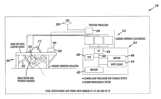
Synopsis
Patent US 8,587,664 B2 describes a target identification and location system and methods thereof, specifically designed for rapid and accurate detection of targets like fires, particularly wildfires. This invention offers a significant advancement in remote sensing by integrating multi-spectral infrared imaging with precise positioning and advanced image processing to overcome limitations of previous systems, such as motion blur, registration errors, and difficulty in distinguishing fire from other hot objects.
A key novel aspect of this invention is the use of multiple infrared imaging sensors (long-wave, mid-wave, short-wave, and very near infrared) to acquire image data across different spectral bands from the same frame of a swath. This multi-spectral approach, combined with a sophisticated image data processing system, enables several critical capabilities:
-
Accurate Band-to-Band and Frame-to-Frame Registration: The system performs a precise band-to-band registration, aligning image data from different infrared bands into one composite frame. This is crucial for accurate target identification based on spectral signatures. Additionally, it performs frame-to-frame registration to produce a full swath mosaic, correcting for sensor motion and allowing for large-area mapping.
-
Enhanced Target Discrimination: By analyzing the infrared image data across multiple bands, the system can reliably identify one or more fire targets. This multi-spectral analysis helps to differentiate actual fires from other hot phenomena, reducing false positives and improving detection accuracy.
Precise Geolocation: The system integrates a positioning system comprising a global positioning system (GPS) and an inertial measurement unit (IMU). This combination provides highly accurate positioning data, allowing the system to determine the precise location of identified targets. The integration with a digital elevation model further refines location data by providing terrain elevation information.
-
Rapid Processing and Analysis: The image data processing system is designed to handle large volumes of data efficiently, performing registrations and target identification in a timely manner. This speed is crucial for applications requiring real-time or near real-time information.
The commercial potential for this target identification and location technology is substantial, particularly in fields requiring rapid and accurate detection and mapping of thermal anomalies:
- Wildfire Management: This system can revolutionize wildfire detection, monitoring, and containment efforts. Its ability to quickly and accurately identify and geolocate fires, even in challenging conditions, allows for earlier response times, more efficient resource allocation, and improved firefighter safety. This is critical for protecting natural resources and human lives.
-
Environmental Monitoring: Beyond wildfires, the technology can be adapted for monitoring other environmental thermal signatures, such as volcanic activity, geothermal areas, or even clandestine industrial emissions.
-
Search and Rescue Operations: The multi-spectral infrared capabilities could aid in locating individuals or objects in low-visibility conditions (e.g., smoke, darkness) during search and rescue missions.
-
Infrastructure Inspection: The system's ability to detect thermal anomalies could be applied to inspect critical infrastructure like pipelines, power lines, or industrial facilities for overheating components or leaks, enabling proactive maintenance and preventing failures.
-
Security and Surveillance: The precise target identification and location capabilities could also be leveraged for security applications, such as detecting intruders or monitoring restricted areas, especially in environments with thermal camouflage.
This invention provides a robust, accurate, and efficient solution for remote target identification and location, with significant implications for enhancing safety, optimizing resource management, and improving situational awareness across various high-stakes applications. Its integrated multi-spectral and geospatial processing capabilities position it as a compelling advancement in remote sensing technology.