NSF CIVIC Project: Bridging Emergency Services and Accessibility for the DHH Community
Project Overview
This NSF Civic Innovation Challenge project addresses a critical need: bridging the gap between essential emergency services and Deaf and Hard-of-Hearing (DHH) individuals. Centered in Monroe County, New York, home to the largest per capita DHH population in the United States, the project brings together academic researchers, emergency management professionals, and DHH community members to collaboratively improve communication, preparedness, and inclusion during emergencies.
Through a combination of geospatial tools, participatory design, and targeted educational initiatives, the project seeks to uncover barriers in emergency response systems and develop scalable solutions that center accessibility and equity. Stage I efforts focused on foundational research, community engagement, and proof-of-concept tools. Stage II expands on this groundwork with a broader, multi-objective approach guided by continued DHH involvement and national applicability.
Key collaborators include Rochester Institute of Technology and the National Technical Institute for the Deaf, the Monroe County Office of Emergency Management, and the Rochester Recreation Club for the Deaf. The project also benefits from the leadership of Deaf principal investigators and the guidance of Deaf external evaluators, ensuring that DHH perspectives shape every stage of the work.
By combining research, technology, and lived experience, this initiative offers a once-in-a-generation opportunity to reshape emergency management systems to be more inclusive, effective, and responsive—locally and nationally.
Stage I Overview
Stage I of the project focused on identifying and addressing emergency communication barriers for DHH individuals in Monroe County, NY. As a pilot initiative under the NSF Civic Innovation Challenge, this stage emphasized deep community engagement, partnership-building, and the development of early tools and simulations to inform future efforts.
Collaborating organizations included the Rochester Institute of Technology and National Technical Institute for the Deaf, the Monroe County Office of Emergency Management, and the Rochester Recreation Club for the Deaf. Together, they worked to surface actionable insights about the intersection of hazards, accessibility, and spatial relationships in emergency response.
Stage II Overview
Stage II of the NSF CIVIC project builds upon the foundational insights from Stage I, taking direct action to address critical gaps in emergency services and communication for Deaf and Hard-of-Hearing (DHH) individuals. Focused initially on Monroe County, NY, this phase is designed for national scalability.
Stage I uncovered two urgent needs: DHH residents face significant barriers in accessing emergency support, and public safety (PS) professionals lack adequate tools and training to serve this community effectively. Stage II introduces a research-centered, community-driven pilot program to co-design and test solutions that directly respond to these findings.
Stage II is organized around four strategic goals:
- Service Gap Goal: Use geospatial technology to assess and close emergency service gaps for the DHH.
- Communication Goal: Design and evaluate inclusive emergency communication tools for DHH individuals and PS professionals.
- Education Goal: Develop educational content to equip PS officials and empower DHH students with emergency preparedness knowledge.
- Workforce Goal: Create professional and volunteer pathways for DHH participation in emergency management systems.
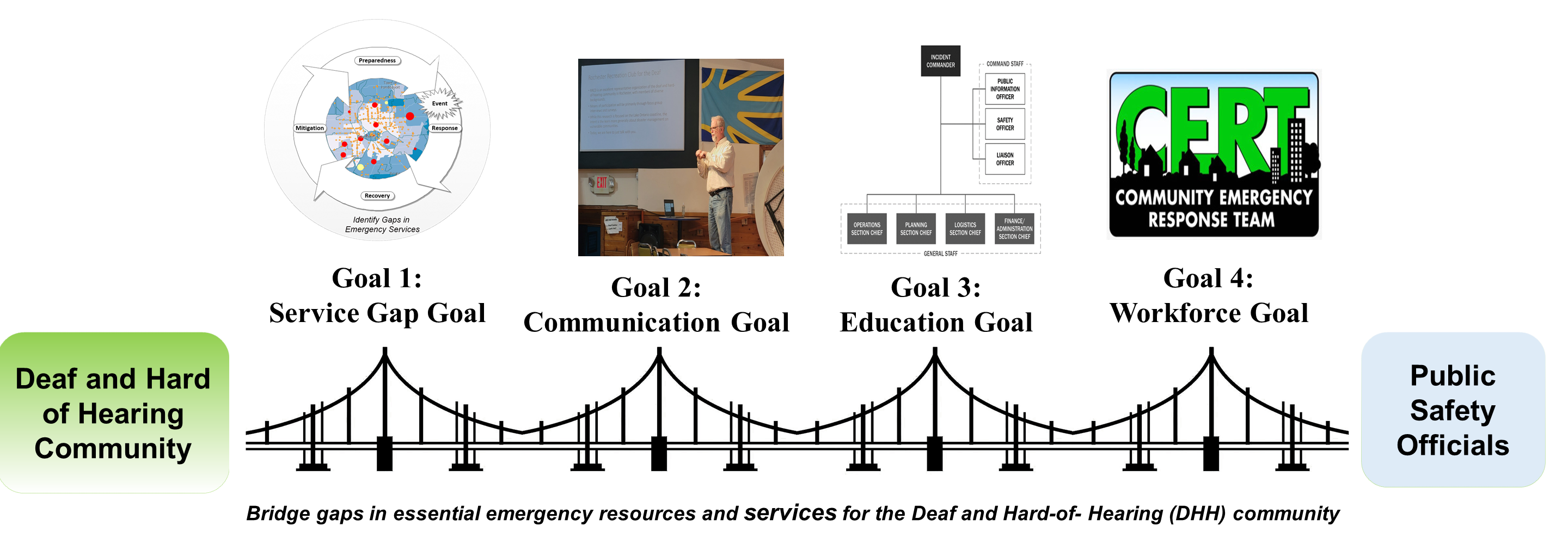
Figure: Graphic summary of the four strategic goals guiding Stage II.
These goals are carried out through seven targeted objectives, each rooted in equity, scientific rigor, and lived experience. Guided by DHH evaluators, academic researchers, and partners from local agencies to the Federal Emergency Management Agency (FEMA), Stage II ensures both practical relevance and national impact.
The overarching vision of Stage II is to transform emergency preparedness through accessible design, inclusive education, and meaningful leadership opportunities for DHH individuals in emergency management nationwide.
Goal 1: Service Gap Goal
Ensuring equitable access to emergency services for the DHH community requires a deep understanding of both systemic service gaps and the unique challenges faced by individuals and institutions. Goal 1 addresses these issues by combining community-driven research with cutting-edge geospatial tools. The two objectives under this goal, focused on service gap assessment and inclusive mapping, lay the foundation for identifying barriers and building tools to strengthen resilience in DHH communities across the nation.
Goal 2: Communication Goal
Communication during emergencies can be a matter of life and death, yet for many DHH individuals, communication barriers remain a persistent challenge. Goal 2 focuses on bridging the service communication gap between public safety officials and the DHH community by designing, developing, and evaluating inclusive tools. Through this goal, we aim to both improve communication from PS officials to DHH individuals, and ensure DHH individuals receive timely and accessible emergency alerts.
The two objectives under this goal target different but complementary aspects of communication. Objective 2a focuses on improving how PS professionals communicate with DHH individuals through a reusable booklet and training program. Objective 2b explores and prototypes new technologies that enable the DHH to directly receive emergency messages in non-auditory formats.
Effective communication between emergency responders and DHH individuals remains a persistent challenge during time-sensitive incidents. To address this, the project team developed and evaluated a reusable, low-cost emergency service communication booklet (called Deaf Community Communication Catalog (DC3)) for use by PS professionals, such as EMS, fire, and police personnel, when interacting with DHH community members.
👉 Access the Free Downloadable PDF and Training Materials
Led by co-PI Dr. Jason Rotoli, MD, this objective builds on medical field communication tools and adapts them for broader emergency management use. The approach involves assessing responders’ baseline comfort levels, delivering targeted training on how to use the booklet, and evaluating the impact through surveys conducted immediately and three months post-training. The hypothesis-driven study assesses whether the intervention improves communication confidence and outcomes in DHH interactions.
The outcome is an open-source, reusable tool that can be adopted by emergency services nationwide. This work not only addresses communication barriers but also serves as a foundation for long-term cultural competency in public safety education.
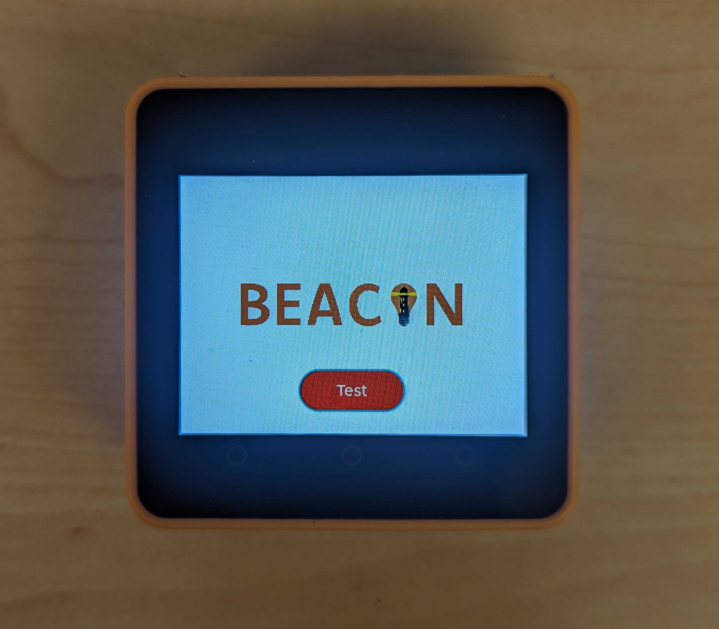
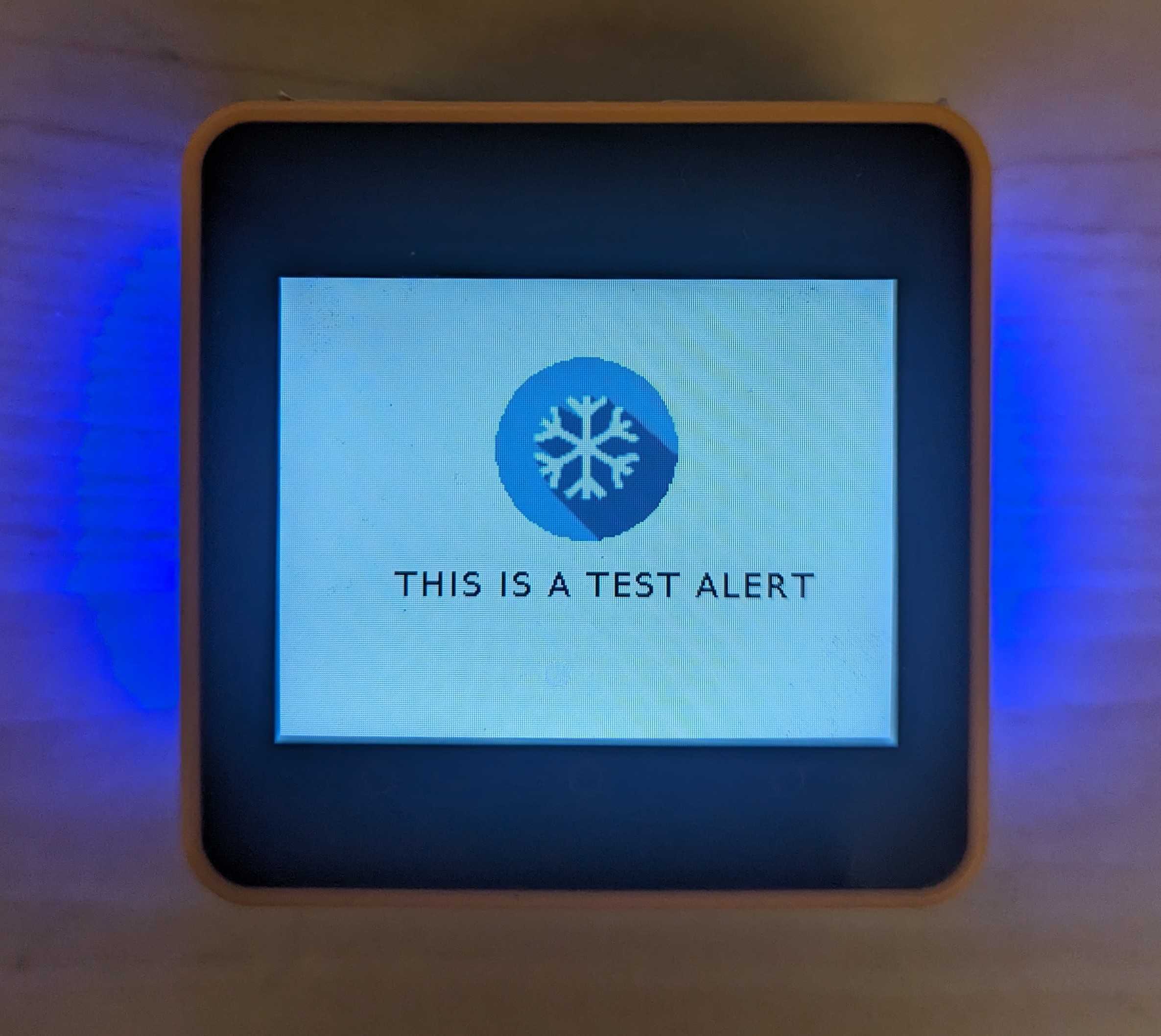
As revealed in Stage 1, many DHH community members face serious challenges with receiving emergency communications. To address this, the project developed and evaluated BEACON (Broadcasting Emergency Alerts: Crisis Outreach and Notification) — an IoT-based system designed to deliver accessible alerts using visual and haptic cues during emergencies.
BEACON is a cloud-based alerting system tailored for the DHH community in Monroe County. The platform connects emergency data sources (e.g., National Weather Service, 911 alerts) to personalized user devices through Amazon Web Services (AWS), using components like IoT Core, SNS, and MQTT. The system supports custom alert preferences, such as colors and vibration patterns, delivered via devices like Raspberry Pi hubs, M5 Stack units, and smart bulbs.
A key innovation is BEACON's Progressive Web App (PWA), allowing users to register devices, configure alert preferences, and manage their accounts in a fully accessible interface. Through collaboration with DHH researchers and stakeholders, the system is designed to ensure real-world usability, privacy, and security.
This system represents a significant advancement over existing alerting devices, which are often expensive, outdated, or not tailored for emergency contexts. Through user-centered design, rigorous prototyping, and evaluation, BEACON aims to offer a scalable, cost-effective solution that can transform how the DHH community experiences emergency communication.
BEACON Prototype
Goal 3: Education Goal
Based on Stage 1 findings, it became clear that many PS professionals lack essential training to effectively serve the DHH community. Goal 3 addresses this critical gap through the creation of educational modules aimed at increasing awareness of Deaf culture, ADA compliance, and inclusive emergency response practices. The long-term vision is to make these modules scalable and sustainable through open-source, FEMA-style course offerings, developed in collaboration with national emergency management partners.
Goal 4. Workforce Development
Stage 1 findings revealed that DHH individuals are largely underrepresented in both public safety and geospatial technology fields. Goal 4 addresses this gap by creating educational and volunteer pathways that support DHH inclusion in emergency management. This includes establishing internship opportunities for DHH students and developing the nation's first Deaf Community Emergency Response Team (D-CERT). These efforts aim to provide long-term career opportunities and deepen DHH participation in public safety infrastructure.
Publications
Research from the NSF CIVIC project has led to multiple publications, highlighting inclusive approaches to emergency management, communication accessibility for DHH communities, and novel technologies to improve community resilience.
- SafeSigns: Enabling Community Resilience Communication for the Deaf and Hard of Hearing
- Inclusive Emergency Alerts: A Cloud-Based Haptic and Visual Notification System for the Deaf and Hard of Hearing
- Disability Inclusion In Local Emergency Management: Evidence From a National Survey of Emergency Managers
Research Outreach
Our project has engaged in extensive outreach, collaboration, and co-design activities with DHH community members, PS partners, and local government agencies. These activities have shaped the development of tools such as SafeSigns, the Deaf Community Communication Catalog (DC3), and training initiatives that strengthen emergency preparedness and resilience.
If you are a civil, government, private sector, or other organization or individual interested in collaborating with us on issues related to the Deaf and Hard-of-Hearing and Emergency Management, please contact Brian Tomaszewski.
For more information about the NSF CIVIC program, visit the NSF Civic Innovation Challenge Webpage.

This material is based upon work supported by the National Science Foundation and the U.S. Department of Energy under Award No. 2322255.