Harmonizing UAS-Based VNIR–SWIR Hyperspectral Imaging for Multimodal Remote Sensing
Principal Investigator(s)
David Messinger
Research Team Members
Amirhossein Hassanzadeh
Jose Macalintal (PhD Student)
Fei Zhang (Postdoctoral Researcher)
Project Description
Multimodal hyperspectral imaging has become an increasingly important tool for remote sensing because different spectral regions capture complementary information about the Earth’s surface. While Visible and Near Infrared (VNIR) imagery provides insight into vegetation vigor and photosynthetic activity, the Shortwave Infrared (SWIR) region is highly sensitive to water content, plant stress, mineral composition, and other biochemical properties. Combining these modalities enables richer scientific analysis than either sensor alone, but accurate data fusion fundamentally depends on precise pixel-level alignment between independently acquired hyperspectral datasets.
Achieving this level of alignment is particularly challenging for airborne pushbroom hyperspectral systems. Unlike framing-array cameras that capture an entire image simultaneously, pushbroom sensors acquire one image row at a time as the aircraft moves through space. High-frequency platform vibrations and the limited sampling rate of onboard inertial measurement units (IMUs) introduce geometric distortions that are often not fully corrected during standard orthorectification, resulting in local pixel misalignment that significantly degrades subsequent hyperspectral fusion and analysis.
To address this challenge, we developed SPLASH (SPatial eLAStic Harmonization), a physics-guided three-stage coregistration framework that progressively removes alignment errors at multiple spatial scales. The workflow first performs rigid coregistration using a multispectral framing-array camera as a stable geospatial reference to correct large global offsets. A novel intermediate stage, called ShapeShifter, leverages the raw pushbroom acquisition geometry to compensate for row-wise distortions caused by roll-induced aircraft motion, an error source largely ignored by conventional registration methods. Finally, elastic registration refines the remaining local non-linear deformations to achieve pixel-level correspondence between VNIR and SWIR hyperspectral cubes. Following spatial harmonization, a wavelength-dependent spectral matching strategy ensures a smooth transition across the overlapping 900–1000 nm spectral region, producing a unified hyperspectral dataset suitable for downstream fusion and analysis.
Evaluation on two independently collected UAS hyperspectral datasets demonstrates that SPLASH consistently improves multimodal alignment both qualitatively and quantitatively. Compared with conventional registration approaches, the framework substantially reduces spatial artifacts, improves correspondence between VNIR and SWIR imagery, and achieves up to an 87% reduction in coregistration RMSE. By explicitly modeling the physical characteristics of pushbroom image acquisition rather than relying solely on generic image registration techniques, SPLASH provides a robust preprocessing framework for multimodal hyperspectral imaging and enables more reliable data fusion for applications including biological sensing, precision agriculture, mineral exploration, and environmental monitoring.
Figures and Images
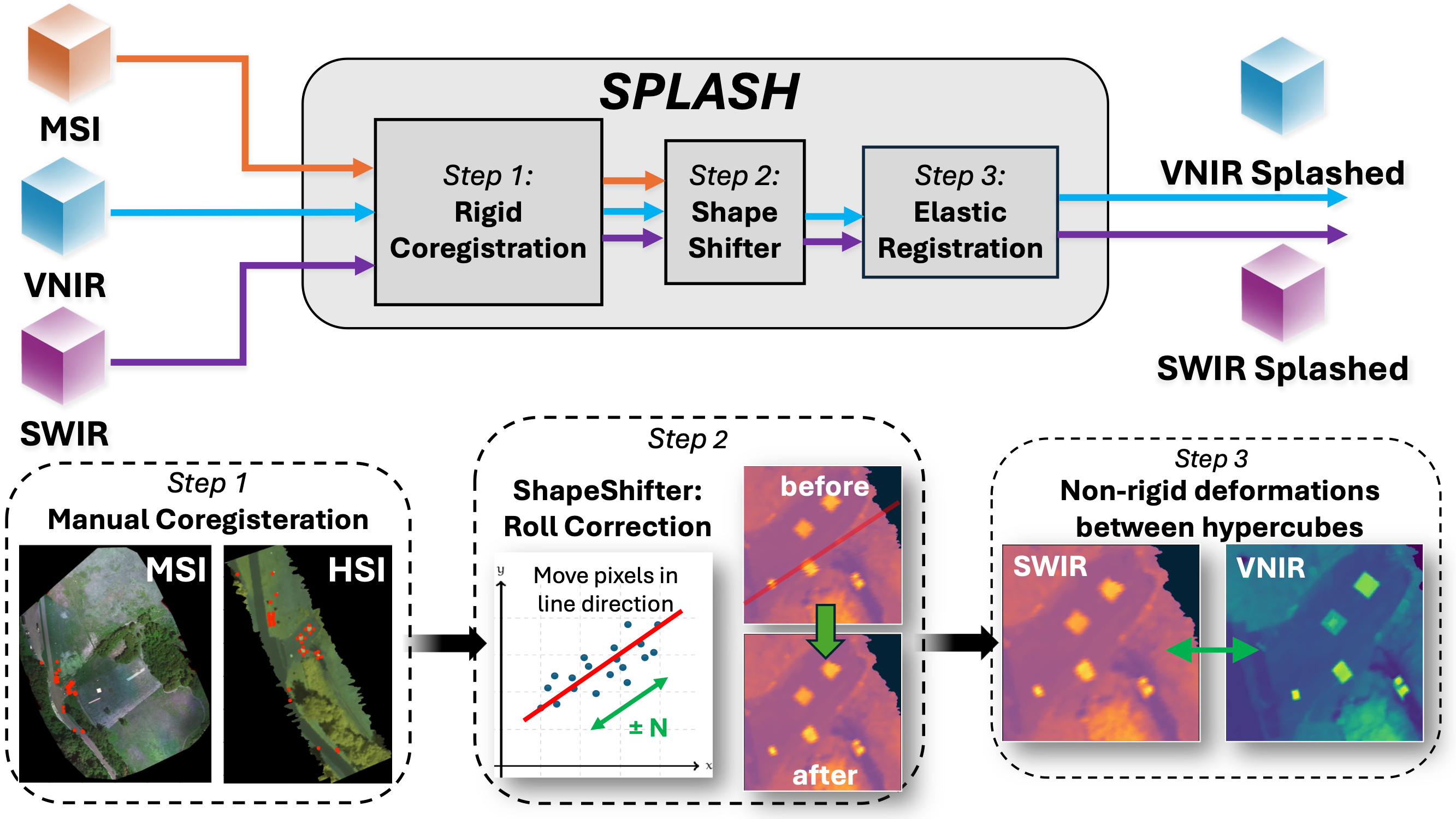
Overview of the proposed SPLASH workflow for harmonizing VNIR–SWIR hyperspectral imagery. The framework consists of three sequential stages. First, rigid coregistration uses a multispectral image (MSI) as a geospatial reference to correct large-scale spatial offsets through perspective warping. Second, the ShapeShifter algorithm compensates for roll-induced distortions by adjusting orthorectified pixel locations based on the original pushbroom acquisition geometry while optimizing an image similarity metric. Finally, elastic registration refines residual local deformations to achieve accurate pixel-level correspondence between the VNIR and SWIR hyperspectral cubes.