News
-
March 25, 2026
Science without borders
Science without borders: RIT turns public participation into global impact.
-
January 28, 2026
Naval Research Lab Sharpens Navy's Sights With Domain-Centric Path for Smarter Sensing
The Department of War speaks to John Kerekes, research professor in the Chester F. Carlson Center for Imaging Science, about the Coastal Hyperspectral Reflectance Object Material Analysis experiment, a part of RIT's Open Community eXperiment (ROCX).
-
September 18, 2025

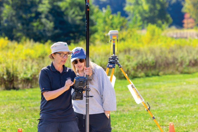
RIT hosts community remote sensing experiment
Satellites, planes, drones, canoes, and more were deployed at RIT’s Tait Preserve for ROCX 2025, an open-community, major data-collection experiment.
-
April 6, 2023

Gift from alumnus Steve Wear will support RIT’s imaging science students and drone lab
A gift from an RIT distinguished alumnus, Steve Wear '91 (imaging science), will help RIT students and researchers reach new heights on the frontier of imaging science.
-
October 11, 2022

RIT researcher receives Department of Energy grant to develop synthetic aperture radar technology
James Albano, a researcher/engineer at RIT’s Chester F. Carlson Center for Imaging Science, has launched a project funded by the Department of Energy to develop remote sensing technology that could have applications ranging from assessing earthquake damage to determining soil moisture for predicting crop yield.
-
February 23, 2022

RIT’s remote sensing experts help scientists keep an eye on the Earth
Scientists from RIT’s Chester F. Carlson Center for Imaging Science recently helped successfully bring the new Landsat 9 satellite online and are partnering with a startup on a bold new initiative to help scientists in government and the private sector monitor changes in the Earth’s surface temperature.
-
January 31, 2022

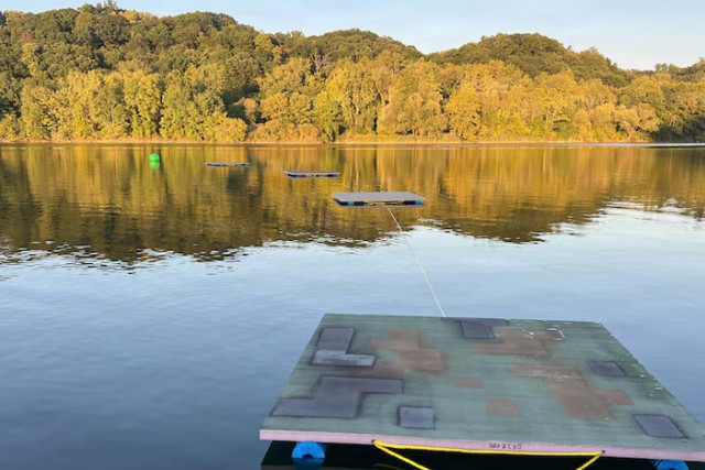
Tait Preserve becoming hotbed for interdisciplinary research
RIT has an emerging new hotspot for interdisciplinary research about 25 minutes from the main campus. The Tait Preserve includes a 60-acre lake and a private mile of Irondequoit Creek adjacent to Ellison Park, offering endless opportunities for research, education, and conservation activities.
-
August 5, 2021

RIT scientists conduct coordinated remote sensing experiments with drones, planes, and satellites
Rochester Institute of Technology scientists and a team of international collaborators recently completed an intricate set of experiments that will help improve remote sensing technology used by drones, airplanes, and satellites.
-
January 15, 2021

Research takes flight at Tait Preserve
Scientists began conducting research at the Tait Preserve of RIT for the first time this summer. Researchers from the Digital Imaging and Remote Sensing Laboratory were the first to use the site, collecting data using imaging technology flown on unmanned aerial systems, or drones.
-
June 23, 2020

RIT’s Digital Imaging and Remote Sensing Laboratory now offering services to the public
Through the Digital Imaging and Remote Sensing (DIRS) Enterprise Center, customers can now hire faculty and staff from RIT’s Chester F. Carlson Center for Imaging Science to provide training, consulting, data collection, equipment calibration and more in relation to drones, imaging and remote sensing technology.
-
May 30, 2020

Screening for Fevers with Thermal Imaging Technology
As states begin to reopen, how will our communities stay safe? Find out how thermal imaging technology is being used as one low-impact screening tool.
-
July 9, 2019

RIT professor receives Jefferson Science Fellowship to serve with U.S. Department of State
Professor John Kerekes will spend the next year advising the U.S. Department of State on issues including its air quality monitoring program and Earth Challenge 2020, the world’s largest ever coordinated citizen science campaign. He is one of 11 faculty nationwide to be selected for a 2019-2020 Jefferson Science Fellowship.