RIT Open Community eXperiment 2025

Thank you to the remote sensing community for an extraordinary response. A major community‑driven data collection effort is now underway behind the scenes.
We were overwhelmed by the level of interest shown by the community in participating in a major data collection experiment to acquire new data for research and education purposes. Working toward a mid‑2026 release of open data, the ROCX Working Group and staff from RIT’s Digital Imaging and Remote Sensing Laboratory are currently compiling the terabytes of data acquired during the September 2025 experiment. Stay tuned for updates. When available, the open data website will be linked from this site.
Support Opportunities
Support This Project
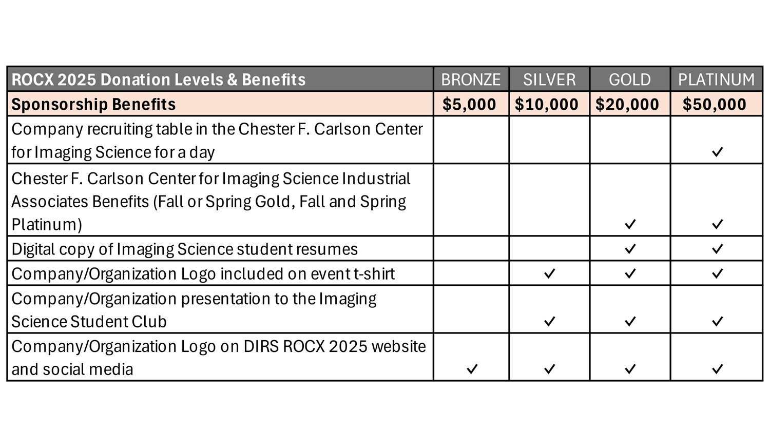
Every gift makes a difference and helps us continue this important work. Help make ROCX 2025 a success! Visit our donation page to contribute.
Want to know more? You can find additional information about sponsorship here.
ROCX 2025 Objectives
The objectives for ROCX 2025 include the following:
- Acquire remote sensing data for research purposes from a variety of sensor modalities and platforms coordinated over a defined area for a defined period.
- Include a range of ground object deployments and ground truth collection activities proposed and carried out by research experiment Principal Investigators.
- Process and distribute analysis ready data sets on an open access data repository for use by the general remote sensing research community.
- Disseminate research results from collection through special sessions at major conferences and peer reviewed journal special issues.
Planning Survey - Update
During the spring and summer of 2024 an open survey was conducted for interest by potential collaboration partners and community participants. We received survey responses from over 60 individuals from more than 40 organizations expressing their interest in ROCX 2025. Of these, 43 individuals from 33 organizations agreed to be part of the ROCX 2025 Working Group which is actively planning details for the experiment. The survey is now closed and further inquiries can be directed to DIRS and will be handled on a case-by-case basis.
Project Updates
October 1, 2025: The intensive ground experiments and data collections have now been completed! We were blessed with wonderfully clear weather and all planned activities (and more) were completed. There was great in-person participation with 75 researchers from 24 organizations (including 13 students from four universities) on-site during the period. Data were acquired by more than a dozen ground instruments, eight UAV platforms, two airplanes and at least six satellite platforms. We now transition to the data compilation phase as we work toward our goal of releasing the data through an open access website by mid-2026.
Read More: RIT hosts community remote sensing experiment
September 1, 2025: Plans are being finalized for the September 8-19 primary experiment period. There are now 19 ground experiments confirmed and 20 remote sensing (and in-situ) data collections confirmed. We anticipate 60+ researchers and students from collaborating organizations and 20+ RIT faculty, staff, and students to be on-site during the two week period. Plans are being made for photographic and video documentation of the activities in addition to the open access scientific database. We’re looking forward to having clear skies and a successful ROCX!
July 1, 2025: Community interest has continued to grow. The ROCX 2025 Working Group now has 93 participants from 60 organizations across 7 countries. We have capped participation at 21 Data Collection proposals and 19 Ground Experiment proposals. We now have plans for an airborne collection by a commercial hyperspectral imager and additional ground experiments, including mine detection, sensing objects on water, material characterization and unmixing, and wetlands and water quality sensing, among others. We are busy developing logistical and coordination plans to accommodate the outstanding community interest.
We are also very pleased to announce the IEEE Geoscience and Remote Sensing Society as a Platinum sponsor! We gratefully acknowledge Matter Intelligence and Spectra Vista Corporation as Bronze sponsors. Thanks to these organizations for their support. Additional support is welcome! Refer to the information at the top of this page.

April 1, 2025: Planning has continued with over 65 participants and 44 organizations in the working group. We continue to plan for an experiment window of September 8 – 19 and have selected RIT’s Tait Preserve as the primary test site. Initial calls for participant proposals yielded the following:
Data collection proposals
- Multiple commercial satellite hyperspectral imaging vendors
- A commercial UAV VNIR/SWIR hyperspectral imaging vendor
- RIT’s multimodal UAV systems (VNIR and SWIR hyperspectral imagers, lidar, multispectral, thermal)
- A commercial UAV magnetometry System (buried metal detection)
Ground experiment proposals
- Hyperspectral subpixel target lattices (~1 m in size with hundreds of pixels for cm-scale imaging from UAV)
- Night time visible point sources for imaging by Landsat and commercial satellites
- Thermal targets for DIRSIG simulation code validation
- Multiple calibration targets (e.g., panels, light sources, mirrors)
- Collection of high resolution point cloud photogrammetry of Tait Lodge
- Ground effluent target bags for gas concentration measurement
The second call for participation propsoals CLOSED on February 28, 2025. Any further inquiries should be sent to the ROCX Coordinators.
Check back periodically for updates to this site. Last Update: February 17, 2026