Operational Atmospheric Water Vapor Estimation for Landsat Surface Temperature Retrieval
Principal Investigator(s)
Aaron Gerace
Eon Rehman
Research Team Members
Amirhossein Hassanzadeh
Robert Mancini (Undergraduate Student)
Matthew Montanaro
Project Description
Thermal infrared satellite observations play a critical role in estimating land surface temperature (LST), supporting applications ranging from precision agriculture and drought monitoring to hydrology, environmental monitoring, and climate science. While the Landsat Collection 3 Split-Window (SW) algorithm provides improved surface temperature retrievals compared with previous operational methods, reliable pixel-level uncertainty estimation remains a significant challenge because atmospheric water vapor is one of the dominant sources of retrieval error yet cannot be directly measured from Landsat Thermal Infrared Sensor (TIRS) observations. Developing an operational framework that accurately characterizes this uncertainty is essential for improving confidence in satellite-derived surface temperature products.
Estimating the atmospheric contribution to surface temperature uncertainty is particularly challenging because TIRS lacks the spectral bands traditionally used to retrieve total precipitable water (TPW). Furthermore, building a robust predictive model requires a large collection of temporally coincident satellite and ground-based observations together with carefully designed features capable of capturing the complex nonlinear relationship between thermal measurements and atmospheric moisture. Any operational solution must therefore integrate both physically based uncertainty modeling and data-driven estimation techniques.
To address these challenges, we developed a comprehensive uncertainty framework for the operational Landsat Split-Window algorithm by combining analytical error propagation with machine learning-based atmospheric modeling. Standard uncertainty propagation was first applied to quantify contributions from sensor noise, surface emissivity, and algorithm coefficients. Because atmospheric water vapor represents a dominant residual source of uncertainty that cannot be directly propagated through the Split-Window formulation, we established its relationship to surface temperature uncertainty using extensive MODTRAN radiative transfer simulations. To operationally estimate TPW, we constructed a large training dataset by pairing Landsat 8 and 9 TIRS observations with temporally coincident MODIS MOD05 satellite water vapor products and AERONET ground-based measurements. A feature engineering pipeline generated physically meaningful thermal predictors and nonlinear feature transformations, followed by automated feature selection using the Jostar optimization framework to identify the most informative predictor subset while minimizing redundancy. Multiple machine learning regression models were evaluated, with XGBoost providing the best balance between predictive accuracy and generalization. The estimated TPW values were then incorporated into the uncertainty propagation framework to generate operational per-pixel uncertainty estimates directly from Landsat observations.
Experimental results demonstrate that the proposed machine learning framework accurately estimates atmospheric water vapor directly from Landsat thermal imagery while providing a practical solution for operational uncertainty estimation. The XGBoost model achieved the highest predictive performance, and the resulting TPW estimates enabled atmospheric uncertainty to be incorporated into the Landsat Collection 3 Split-Window uncertainty workflow without requiring external atmospheric products during operational processing. Collectively, these results demonstrate that combining physically based uncertainty propagation with machine learning, feature engineering, and automated feature selection provides a robust framework for improving uncertainty estimation in satellite-derived land surface temperature products.
Figures and Images
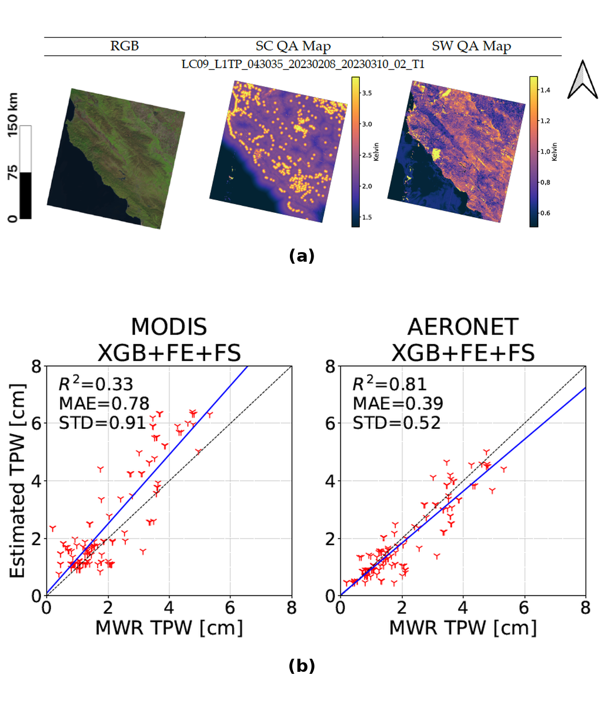
Overview of the proposed atmospheric water vapor estimation and uncertainty framework. (a) RGB imagery alongside the Single-Channel (SC) and Split-Window (SW) quality assurance (QA) maps for representative Landsat scenes. The SC QA maps exhibit the characteristic “lollipop effect” caused by the distance-to-cloud parameter and cloud-related false positives, whereas the SW QA maps incorporate TPW estimates generated using the AERONET-trained XGBoost model with feature engineering and feature selection (XGB+FE+FS) to produce physically based uncertainty estimates. (b) Comparison of machine learning-derived total precipitable water (TPW) estimates against independent microwave radiometer (MWR) reference measurements. The left panel shows results for the MODIS-trained model, while the right panel presents the AERONET-trained model.