RadSCape: Radiative transfer simulation and validation of the dynamic structural and spectral properties of the vegetation of the Cape
Principal Investigator(s)
Jan van Aardt
Research Team Members
Ramesh Bhatta (PhD Student)
Manisha Das Chaity (PhD Student)
Michael Saunders
Byron Eng
Jacob Irizzary
Jasper Slingsby (University of Cape Town, South Africa)
Glenn Moncrieff (The Nature Conservancy, South Africa)
Project Description
The Greater Cape Floristic Region (GCFR) in South Africa is a hyper-diverse region encompassing two global biodiversity hotspots. It is increasingly threatened by habitat loss and fragmentation, invasive species, altered fire regimes, and climate change. Managing and mitigating these threats requires regularly updated, spatially explicit information across the entire region, which is currently only feasible through satellite remote sensing. However, detecting ecological change is particularly challenging because spectral signals are confounded by the region's exceptional spectral and structural heterogeneity, spanning variation at the leaf, stem, and whole-crown scales. This complexity is further amplified by the extraordinary plant diversity characteristic of the GCFR.
To address these challenges, we developed a physics-based simulation framework that integrates fynbos trait measurements with radiative transfer modeling in the DIRSIG environment to quantify information loss across spectral and spatial scales and establish theoretical limits for biodiversity monitoring. We constructed a three-dimensional virtual representation of post-fire fynbos communities in the Grootbos Private Nature Reserve by integrating high-resolution imagery, terrestrial laser scanning (TLS), structure-from-motion (SfM)-derived point clouds, and field measurements. Species abundance and vegetation structure were constrained using field-derived mean crown diameter and percent cover measurements. The resulting virtual scene was used to simulate multispectral (DJI Mavic 3 MSI), hyperspectral (AVIRIS-NG), and light detection and ranging (LiDAR) observations. Simulated datasets were validated against corresponding field-acquired observations using spectral signatures and vegetation indices. This open-source framework enabled us a systematic evaluation of how sensor spectral and spatial characteristics influence spectral biodiversity metrics and provided a foundation for assessing the theoretical limits of species discrimination across remote sensing platforms.
Figures and Images
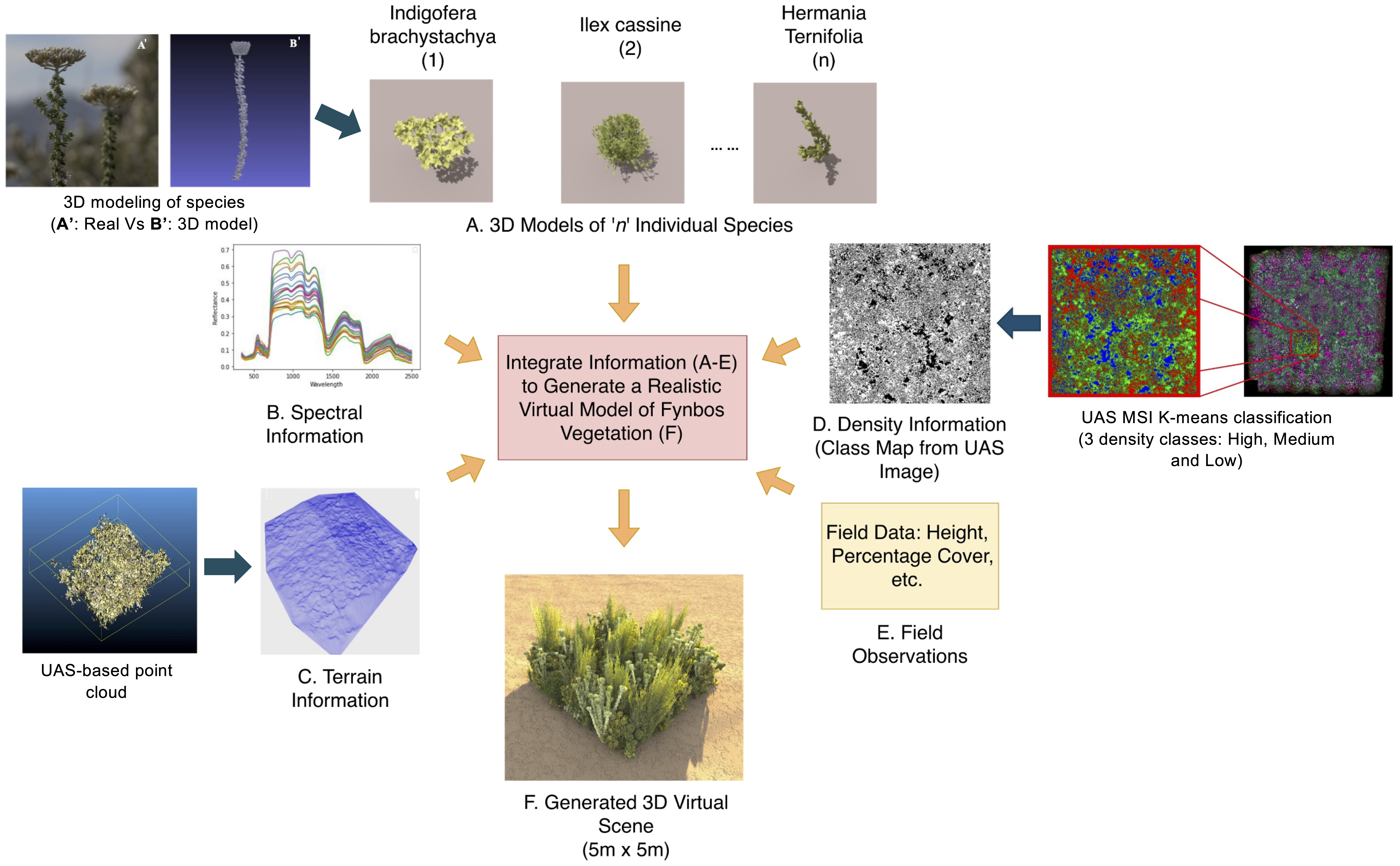
Scene generation workflow. Virtual 3D Fynbos scene constructed by integrating spectral properties (reflectance and transmittance from field measurements), 3D structural models of individual species, terrain information, and field-collected ecological data to create a physically realistic simulation environment.