Advancing Operational Landmine Detection Through UAV-Based Multi-Sensor Sensing and Artificial Intelligence
Principal Investigator(s)
Emmett Ientilucci
Research Team Members
Sagar Lekhak (PhD Student)
Project Description
Landmines and unexploded ordnance (UXO) continue to threaten civilian populations decades after conflicts end, while conventional clearance operations remain slow, labor-intensive, hazardous, and expensive. The overarching goal of this research is to improve operational landmine detection through UAV-based multi-sensor data collection, advanced remote sensing, artificial intelligence (AI), and data-driven decision making. By combining complementary sensing modalities, including RGB, hyperspectral, multispectral, thermal infrared, LiDAR, synthetic aperture radar (SAR), airborne metal detection, magnetometry, and ground-penetrating radar (GPR), this research aims to develop robust sensing and AI frameworks that accelerate humanitarian demining while improving detection reliability across diverse environments. Rather than focusing on a single sensor or algorithm, the project investigates how sensing technologies, machine learning, benchmark datasets, uncertainty quantification, and operational workflows can be integrated into practical decision-support systems for field deployment.
Handheld metal detectors remain the gold standard for humanitarian demining; however, the process is labor-intensive and time-consuming. Our first effort evaluated the feasibility of UAV-mounted electromagnetic induction systems as an alternative to conventional handheld metal detectors. The study demonstrated the potential of airborne metal detection to rapidly survey large areas while reducing operator exposure to hazardous environments.
To accelerate the detection of surface-laid landmines, we introduced one of the first publicly available UAV-based hyperspectral benchmark datasets for humanitarian demining. The dataset provides calibrated imagery, reference spectra, and annotated targets, establishing a common platform for developing, benchmarking, and objectively evaluating hyperspectral target detection algorithms.
Building upon this benchmark, we systematically compared classical statistical target detectors with lightweight deep-learning approaches for detecting surface-laid PFM-1 landmines. The study emphasized operationally meaningful evaluation using both ROC and precision-recall analyses, providing practical insights into algorithm performance under the highly imbalanced conditions encountered in humanitarian demining.
To improve the reliability of AI-assisted detection, we investigated Bayesian uncertainty estimation for deep-learning classifiers. By quantifying predictive confidence, this work explored how uncertainty information can help operators distinguish reliable detections from uncertain predictions, enabling safer and more informed decision making during humanitarian mine action.
Most recently, we conducted one of the most comprehensive comparisons of sensing technologies for humanitarian demining. Using 34 co-registered datasets collected from nine sensing modalities, the study quantitatively evaluated the capabilities of optical and geophysical sensors and provided practical guidance for selecting sensing technologies based on target type, burial depth, and environmental conditions.
Current research extends these foundations toward next-generation AI-enabled operational systems. Ongoing efforts focus on developing refined benchmark datasets, improving domain generalization across locations and flight altitudes, investigating multi-sensor fusion and explainable AI, incorporating uncertainty-aware decision support, and exploring adaptive human-AI collaboration. Collectively, these efforts aim to bridge the gap between laboratory research and deployable UAV-based systems that improve the speed, safety, and effectiveness of humanitarian demining operations.
Figures and Images
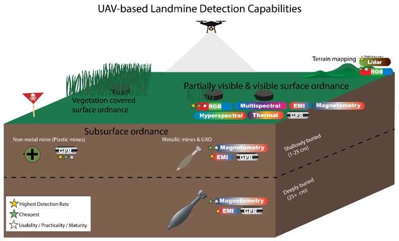
Illustration of different UAV-based landmine and UXO detection capabilities divided by problem set. The colored stars indicate which modality has the highest detection rate, cheapest, and most mature/practical depending on the star color.