Fundamental image science research
Principal Investigator(s)
Emmett Ientilucci
Research Team Members
Carl Salvaggio, Jan van Aardt, Michael Gartley, Donald McKeown, Tim Bauch, Nina Raqueño, Mohammed Yousefhussien, Alex Fafard, Prasanna Reddy Pulakurthi
Project Description
This project performs fundamental research into the end-to-end performance and evaluation of remote sensing imaging systems and the exploitation of image data from such systems. The overall focus is to perform research on topics such as:
- semantic understanding of point cloud data (i.e., 3D /LiDAR processing),
- novel multi-modal image registration techniques (using CNN’s),
- anomaly, change and glint-type detection algorithms,
- shadow detection in aerial imagery,
- UAS data collections, processing, and storage techniques,
- production of pixel-wise confidence estimates in disparity maps produced through stereoscopic techniques, and
- DIRSIG SAR capabilities and image generation.
The Automated 3D Change Detection project is working towards the generation and leverage of a pixel-wise confidence estimate in imagery depth maps produced through stereoscopic techniques namely the semi-global matching method. The 3D point cloud project aims to provide a semantic understanding of aerial data when point cloud information (structural information) is provided. We have developed, tested and published a unique point cloud labeling algorithm in 2019. Registration research is in the area of multi modal, non-rigid, registration using deep learning techniques. We have developed a technique that is currently be tested and evaluated against a few state-of-the art approaches, some used in the medical imaging community. In the area of unmanned aerial systems, we continue to collect data over a specific sites using our multi-model UAS systems. All the data is hosted on a custom ESRI image server we have designed. We will soon be collecting data using our new SWIR sensor. We have also recently executed a series of DIRSIG simulations for both oblique Synthetic Aperture Radar (SAR) and nadir panchromatic payloads. The shadow detection work has produced a series of machine learning algorithms utilizing a CNN to detect shadows in aerial imagery.
Figures and Images
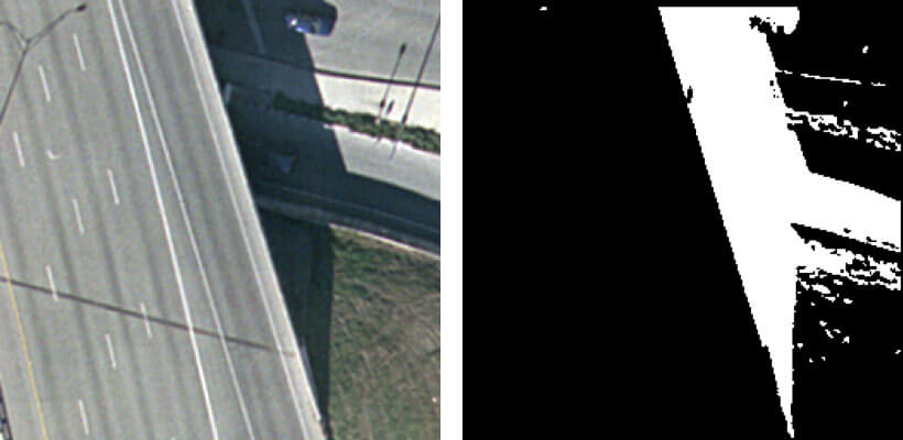
Shadow detection using a CNN machine learning technique.