Globally-Derived Measures of Structure Informed by Ecological Theory and Observation
Principal Investigator(s)
Research Team Members
Tahrir Siddiqui
External Collaborators:
Brandon Alveshere (VCU)
Chris Gough (VCU)
Keith Krause (Battelle)
Sponsor:
NASA (Decadal Survey Incubation)
Project Description
The objectives of this project are to i) Identify existing and novel vegetation structural metrics, akin to leaf area index (LAI), that are strongly correlated with ecosystem function and broadly useful to advancing ecological knowledge at multiple spatial scales; ii) Develop processing algorithms to derive ecologically significant vegetation structural metrics from “next generation” spaceborne LiDAR instruments; and iii) assess the capabilities and limitations of current LiDAR systems to produce ecologically meaningful next generational data products.
Accurate and scalable estimation of forest production is essential for quantifying carbon sequestration, forecasting timber yields, and guiding climate change mitigation strategies. While prior studies established a linkage between net primary production (NPP) and canopy structural complexity (CSC) metrics from terrestrial LiDAR, the spatial coverage of ground-based surveys is limited. Airborne laser scanning (ALS) offers a rapid and spatially extensive alternative to terrestrial scanning but using CSC metrics derived from ALS to estimate forest production is insufficiently explored. We addressed this knowledge gap using a suite of 3D CSC metrics derived from small-footprint ALS data. Data were acquired by the National Ecological Observatory Network’s (NEON) Airborne Observation Platform (AOP), for modelling NPP in deciduous, evergreen, and mixed forests across six ecoclimatic domains in the United States. We assessed how the resolution used to derive CSC metrics influences NPP prediction accuracy, offering insights into the spatial scales at which CSC traits regulate plot-scale forest production.

Figure 1: Illustration of the derivation of our raster-based 3D CSC metrics. Eight out of nine metrics we derived are raster-based. Top: A column from the point cloud of a forest plot gridded at 1m2 resolution. Portions of the canopy described by the computed raster values are labelled along with the corresponding metric in parenthesis. Bottom: Raster-based metrics were computed from 1m up to 10m resolution in each 40x40m plot to assess scale-sensitivity.
We employed a novel modeling framework that combines Partial Least Squares regression with cross-validation and Recursive Feature Elimination to identify optimal combination of metrics for estimating plot-scale NPP. The best model for each forest type explained a high amount of variance in NPP, with three CSC metrics explaining 77% of variance in deciduous forests (RMSE% = 11%) and another three accounting for 76% of variance in evergreen forests (RMSE% = 13%). No statistically significant models were identified for mixed forests, suggesting that the structural attributes influencing plot-scale NPP differ between deciduous and evergreen forests. The 3D CSC metrics identified as strong NPP predictors hold promise for enabling accurate estimation of stand-scale production in temperate deciduous and evergreen forests using small-footprint ALS data. Our manuscript for this study, titled “Modeling primary production in temperate forests using three-dimensional canopy structural complexity metrics derived from airborne LiDAR data”, is currently under review in MDPI’s Remote Sensing journal under the special issue Digital Modeling for Sustainable Forest Management.
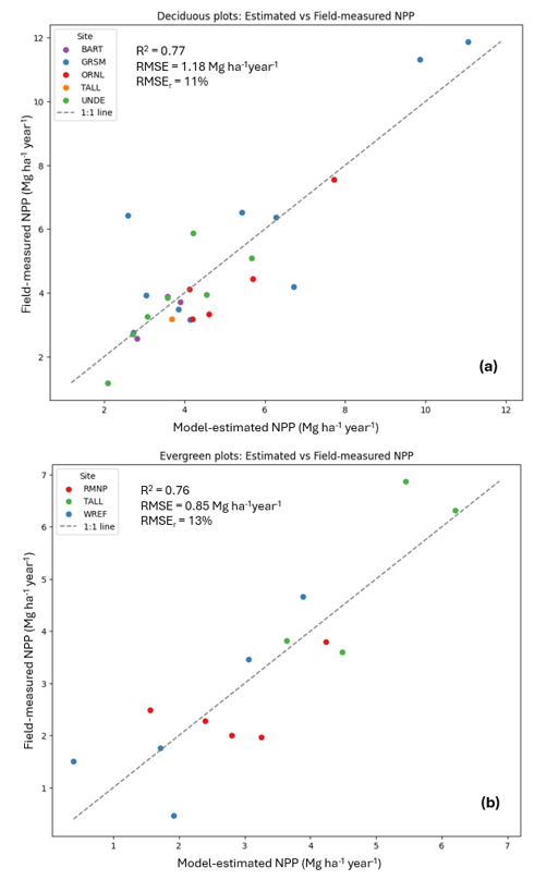
Figure 2: Top: Fit for best deciduous model. Bottom: Fit for best evergreen model.
Currently, we are developing models to retrieve ecologically significant structural metrics, including the CSC metrics identified in our prior analysis, from spaceborne LiDAR systems by leveraging large-footprint, full-waveform data acquired by NASA’s Land, Vegetation, and Ice Sensor (LVIS) – a high-altitude airborne sensor that provides calibration data for spaceborne LiDAR. We are utilizing LVIS data collected at the Smithsonian Environmental Research Center (SERC), where extensive spatial and temporal overlap between LVIS and NEON data enables robust model training. With approximately 100,000 co-located LVIS-AOP samples available, we are employing transformer-based deep learning architectures to reconstruct high-resolution ALS hit-grids from the sparser LVIS waveforms, facilitating extraction of structural complexity metrics.
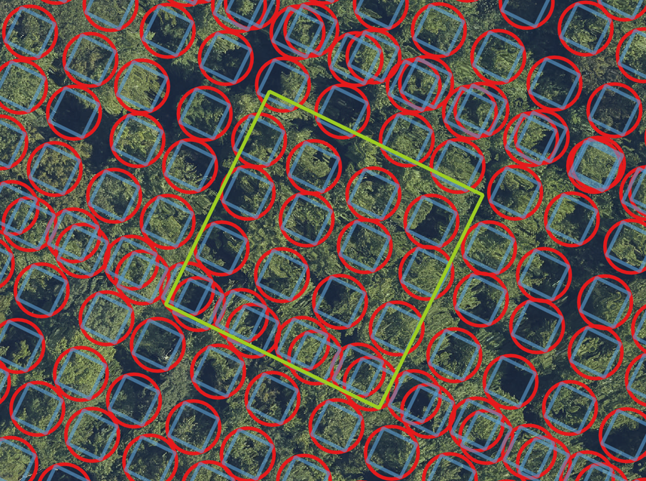
Figure 3: LVIS shots (red circle) and overlapping AOP point cloud columns (blue square) at the SERC forest site. We are employing transformer-based models to accurately up-scale the LVIS waveforms using co-located AOP hit-grids as ground truth.
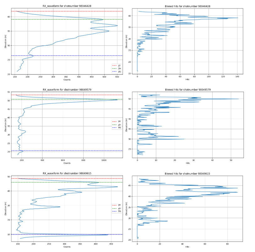
Figure 4: The co-located ALS hit-grid, binned at 0.15m, are to the right of each LVIS return waveform.
References
[1] Alveshere, B. C., Siddiqui, T., Krause, K., van Aardt, J., and Gough, C. Hemlock woolly adelgid (adelges tsugae) infestation influences forest structural complexity and its relationship with primary production. Available at SSRN 5006994 (2024).
[2] Alveshere, B. C., Siddiqui, T., Krause, K., van Aardt, J. A., and Gough, C. M. Hemlock woolly adelgid infestation influences canopy structural complexity and its relationship with primary production in a temperate mixed forest. Forest Ecology and Management 586 (2025), 122698.
[3] Gough, C. M., Alveshere, B., Siddiqui, T., Ogoshi, M., van Aardt, J. A., LaRue, E. A., and Krause, K. Advances and opportunities in the characterization of vegetation structure: An ecologist’s perspective. In AGU Fall Meeting Abstracts (2024), vol. 2024, pp. GC54E–02.
[4] Siddiqui, T., Alveshere, B. C., Gough, C., van Aardt, J., and Krause, K. Estimating forest productivity using three-dimensional canopy structural complexity metrics derived from small-footprint airborne lidar data. Available at SSRN 5022638 (2024)