Landsat system engineering studies
Principal Investigator(s)
John Kerekes
Research Team Members
Nicholas Bitten, Zhaoyu Cui, Keegan McCoy, Emily Myers, Grady Saunders, Scott Brown, Rolando Raqueño, Jared Van Cor
Project Description
As NASA prepares to define the next generation of Landsat earth observing systems, this project has been exploring requirements for these future systems. Topics studied include:
- Impacts of wide-swath imaging including the potential for spectral shifts in channel bandpasses;
- Improved vegetation parameter retrievals from additional red-edge spectral bands;
- Methods for characterization and specification of stray light requirements in reflective spectral bands;
- Requirements for temporal sampling and satellite re-visit rates in agricultural applications.
- Sensitivity of spectral band artifacts in longwave infrared band filters to surface temperature retrieval accuracy.
- Efficient and realistic simulation of vegetation growth and resulting imagery.
Examples of a few of the above topics are included in the accompanying figures. The figure to the right shows an example simulated image from a new workflow merging the detailed stray light modeling for a given optical imaging system together with an accurate scene upwelling radiance map.
This work enables the accurate study of the impacts of stray light on scientific products from satellite imagery. The figure to the left shows NDVI time-series data derived from PlanetScope satellite imagery collected in collaboration with US Department of Agriculture researchers for a corn field at the Beltsville Agricultural Research Center. The data were fit to a temporal shape model which was used to estimate phenological transition dates as part of studies exploring the temporal sampling requirements for future land imaging satellites. The figures below illustrates examples of a continuous-time growth model used to drive geometric parameterization of corn plants which consider spatiotemporally-varying environmental variables in support of the study on temporal sampling requirements.
Project Status:
The overall project ended at the close of the 2018-19 academic year, although some of the studies will continue.
Figures and Images
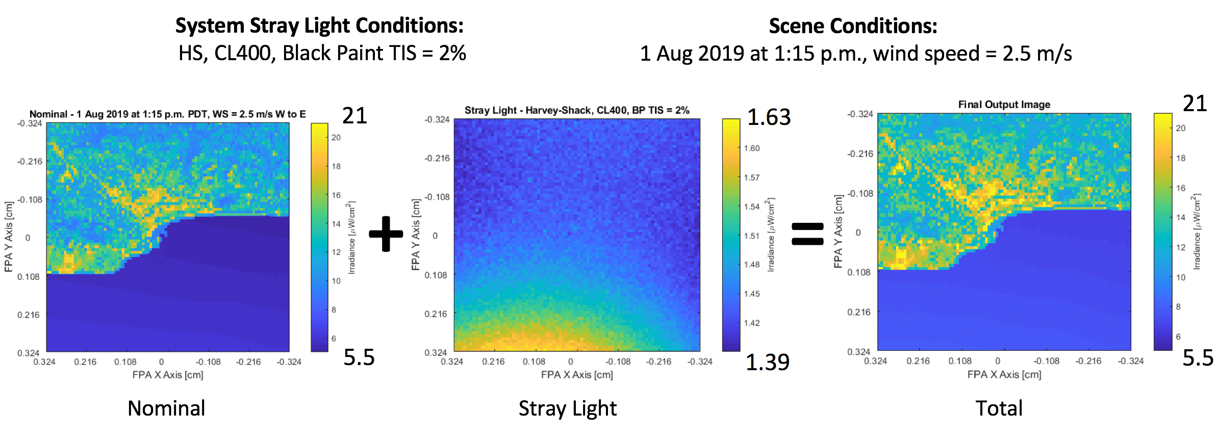
Simulated satellite imagery of the coastal area near Santa Barbara, CA, showing the result from merging scene-dependent stray light together with nominal light imaged through a designed optical path. This new capability supports novel end-to-end studies of the impact of stray light on satellite image user applications.
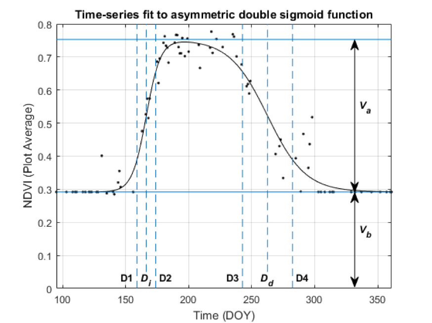
Plot-average NDVI time-series fit to asymmetric double sigmoid function, with fitting parameters and estimated phenological transition dates (D1-D4) labeled.
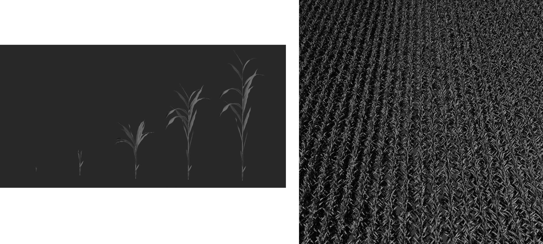
Individual computer-rendered images of corn at various stages of growth (left) and an efficiently rendered high resolution image of a field of corn plants (right).