Radiative Transfer and Statistical Models for Sediment and Vegetation Parameters from Hyperspectral Imagery
Principal Investigator(s)
Research Team Members
Research Team Members:
Anthony Luby (Ph.D.)
Kevin Donnelly (MS)
Chris H. Lee (Ph.D.)
Nayma Binte Nur (Ph.D.)
Lauren Mowrey (BS)
Grace Kachmaryk (BS)
Kyle Cummings (BS)
Nickolas Villante (BS, Physics)
External Collaborators:
A. Christina Tyler (RIT Environmental Science)
Wendy Owens-Rios (SUNY Geneseo)
Nimrod Carmon (JPL)
Project Description
Over a number of years, the Bachmann laboratory (GRIT Lab) has been developing and improving radiative transfer and advanced statistical/AI models that can be used to invert key biophysical and geophysical parameters of sediment and vegetation from hyperspectral and multi-sensor imagery, particularly in coastal environments, with an emphasis on wetland ecosystems. Some of this ongoing research has leveraged a past project that was supported in part by the National Geographic Society (A. C. Tyler and C. M. Bachmann, investigators) entitled: “Improving Estimates of Salt Marsh Resilience and Coastal Blue Carbon,” focused on study areas at the Virginia Coast Reserve (VCR) Long-Term Ecological Research (LTER) site. In this past project, we had undertaken a series of four extensive remote sensing and field ground truth data collection campaigns at the VCR LTER over a three-year period (2017-2019). The extensive data collected by us during these campaigns has formed the basis of our past publications on retrieval of key soil and vegetation parameters from both drone-based remote sensing and other similar near-surface remote sensing platforms that provide very high-resolution imagery and supported continued ongoing research in GRIT Lab. Hyperspectral imagery from both drones and our mast-mounted platform (Bachmann et al, 2019), including data from these systems collected at the VCR LTER, has played a foundational role in our models of coastal sediment and vegetation properties, enabling coastal zone mapping products using radiative transfer as well as statistical/AI models.
Salt marsh vegetation and soils are highly efficient ecosystems for sequestering carbon, and above-ground biomass is one of several related key variables. Some of our first predictive models of vegetation biophysical parameters from the VCR LTER studies focused on retrieving this variable using the PROSAIL radiative transfer model (Eon et al, 2019) from mast-mounted hyperspectral imagery, while we also explored advanced statistical/AI models for other parameters such leaf foliar nitrogen, plant stress, and soil parameters such as salinity and oxidation reduction potential (ORP) (Goldsmith et al, 2020). Soil moisture content also plays a significant role in coastal ecosystems, and we have utilized and improved radiative transfer models to estimate this critical variable from hyperspectral remote sensing (Eon and Bachmann, 2021; Nur and Bachmann, 2023); accurate characterization of soil moisture content is also critical because it impacts the ability to accurately retrieve other important variables such as soil carbon. A similar statement can be made for soil roughness: it is a key parameter playing a role an important role in ecosystem nutrient flux, but it is also potentially a confounding variable in retrieving other soil and vegetation parameters. Building accurate radiative transfer models to retrieve this variable, therefore, has been another important focus, using both lab hyperspectral data (Shiltz and Bachmann, 2023) as well as in practical application to satellite imagery (Carmon et al, 2023). Using drone hyperspectral imagery from the VCR LTER campaigns, our more recent related work has focused on retrieval and mapping of a number of key soil variables including soil organic matter, total carbon, and total nitrogen (Figure 1; Nur, Bachmann, Tyler, et al, 2025). Another new focus area in our current research leverages both our work in radiative transfer and statistical/AI models for vegetation and soil geophysical and biophysical parameters and the extensive hyperspectral imagery and ground truth at the VCR LTER to build predictive models that map the biodiversity of marine invertebrate species in coastal salt marsh systems.
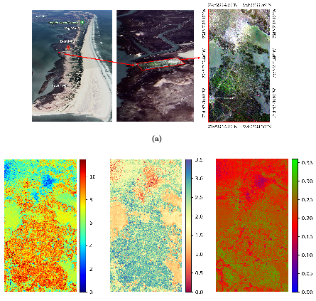
Figure 1: (Top) UAS hyperspectral wetland scene projectd onto a Google Earth view of Hog Island at the VCR LTER. (Bottom) Maps of soil organic matter, total carbon, and total nitrogen retrieved from the hyperspectral imagery using our model.
Our recent research has also leveraged data collected in another of our past projects, an NSF Convergence Accelerator project in 2023, undertaken by us in partnership with Cornell Civil & Environmental Engineering and CHESS, CSIRO, and Phoenix Tailings and entitled "“Accelerating Use of Geologically-driven Engineering and Reclamation (AUGER), A Predictive Approach to a Sustainable Critical Minerals Industry." This earlier project considered complimentary measurement capabilities: x-ray fluorescence (XRF) (at CHESS) and hyperspectral imaging (RIT) for characterizing and repurposing mine waste (tailings). In our current work, we have continued to use hyperspectral imagery collected by us during a project field campaign at a mining site to explore topics related to mineral characterization, particularly important parameters such as grain size. In some of our most recent related work, we have undertaken carefully controlled laboratory studies and developed new more effective models for polarimetric hyperspectral imagery that can be used to predict grain size using both polarized angular hyperspectral data from our hyperspectral goniometer (Lee, Bachmann, Nur, and Golding, 2025) and our hyperspectral imaging mast system ( Golding, Lapszynski, Bachmann, and Lee, 2023).
To further increase the accuracy of all of our modeling efforts, we have also focused on improving the calibration of remote sensing imagery that is the input to our models. To that end, we have used our hyperspectral goniometer (Harms, Bachmann, et al, 2017) to characterize the bi-directional reflectance distribution function (BRDF) of calibration reference standards, which, in many remote sensing processing chains, are assumed to be perfectly Lambertian. Our hyperspectral BRDF measurements illustrate the non-Lambertian nature of these calibration reference standards, and we have developed accurate models for these hyperspectral BRDF measurements of calibration reference standards and demonstrated workflows that incorporate these models for use when remote sensing imagery is collected in field settings, significantly improving the radiometric accuracy of the resulting imagery data (Lee, Bachmann, et al, 2024).
References
[1] Lee, C. H., Bachmann, C. M., Nur, N. B., and Golding, R. M. Bidirectional spectro-polarimetry of olivine sand. Earth and Space Science 12, 1 (2025), e2024EA003928.
[2] Lee, C. H., Bachmann, C. M., Nur, N. B., Mao, Y., Conran, D. N., and Bauch, T. D. A comprehensive brf model for spectralon and applica- tion to hyperspectral field imagery. IEEE Transactions on Geoscience and
Remote Sensing 62 (2024), 1–16.
[3] Nur, N. B., Bachmann, C. M., Tyler, A. C., Miller, A., Khan, S., Union, K. E., Owens-Rios, W. A., Bauch, T. D., and Lapszynski, C. S. Mapping soil organic matter, total carbon, and total nitrogen in salt marshes using uas-based hyperspectral imaging. Journal of Geophysical Research: Biogeosciences 130, 6 (2025), e2024JG008421.