RadSCape: Radiative Transfer Simulation and Validation of the Dynamic Structural and Spectral Properties of the Vegetation of the Cape
Principal Investigator(s)
Research Team Members
Research Team:
Ramesh Bhatta
Manisha Das Chaity
Grady Saunders
Byron Eng
Jacob Irizarry
Jasper Slingsby
Glenn Moncrieff
Sponsor:
NASA BioSCape Program
Project Description
The Cape Floristic Region (CFR) in South Africa is a hyper-diverse region encompassing two global biodiversity hotspots threatened by habitat loss and fragmentation, invasive species, altered fire regimes, and climate change. Managing and mitigating these threats requires regularly updated, spatially explicit information for the entire region, which is currently only feasible using satellite remote sensing. However, detecting the signal change over the spectral and structural variability of ecosystems in the region is highly challenging due to the exceptionally high ecosystem diversity and the confounding influence of structural variables at the leaf, stem, and whole-crown scales. This complexity is exacerbated by the fact that CFR contains spectacular plant diversity.
The objectives of this study are to build digital twins of multiple post-burn plots in the CFR by combining fynbos (the dominant biome in the region) trait measurements with radiative transfer modeling in a biophysically and physically robust simulation environment. These digital twins will be validated using field-collected spectral and structural data. Subsequently, through simulations of various spectral and LiDAR sensors, we aim to inform the design of next-generation remote sensing systems capable of monitoring post-fire recovery in the region. Achieving this goal will significantly improve our understanding of light interactions within the fynbos biophysical traits and inform innovative use of remote sensing data for such highly diverse ecosystems at all scales, from airborne to satellite levels. Overall, this study presents a novel framework for simulating and leveraging remote sensing-based land surface reflectance and structural properties, in a region with exceptional ecosystem diversity, which could have important implications for the management and conservation of the GCFR.
Our team focused on conducting extensive fieldwork in the second year of the BioSCape project to explore the diverse fynbos ecosystem in South Africa. We visited the Grootbos Private Nature Reserve in South Africa in October 2023 to collect field samples and drone data. We collected multispectral imagery for a subset of the total reserve area using a DJI Mavic 3 Multispectral drone, for six different burn years. In each of the burnt sites, we selected a sampling area near the center of the flight zone and estimated the percentage cover and the average height of each species that occurred within the plots to estimate species richness within each plot.
We exhaustively collected spectral measurements for various species at the leaf-level, for flowers, background, and invasive species in the range of 350-2500nm, using an Analytical Spectral Device (ASD). We used the collected fieldwork data to ensure we covered the variation in fynbos structural and spectral traits. The fieldwork was supported by Dr. Jasper Slingsby (UCT), Dr. Glenn Moncrieff (SAEON), and Mr. Sean Privett (botanist; consultant), as well as the Grootbos Nature Reserve research personnel.
Building upon the success of Year 1, we have worked on refining our scene-building process in DIRSIG to enhance its accuracy and efficiency. This involved integrating advanced scene-building tools, making 3D objects of plant species, improving the PROSPECT model, and incorporating more sophisticated spectral data from our 2023 field trip. We also have incorporated the drone data to track changes in biodiversity and habitat conditions over the Fynbos region, to gain invaluable insights into ecosystem resilience and adaptation. By the end of Year 2, the virtual scenes representing different post-fire stages of fynbos are fully developed and ready for use. Capabilities to simulate individual species with varying densities, area coverage, and overlap have been incorporated, enabling precise tuning of scene properties for simulation studies.
Figure 1 illustrates the scene generation capabilities of the fynbos species and burn plots in Grootbos private nature reserve. The integration of scene-building tools and comprehensive assets has greatly enhanced our ability to simulate the diverse ecosystem of fynbos within the DIRSIG framework. These virtual scenes also expand our capacity to evaluate the effectiveness of imaging instrument in capturing this complexity.
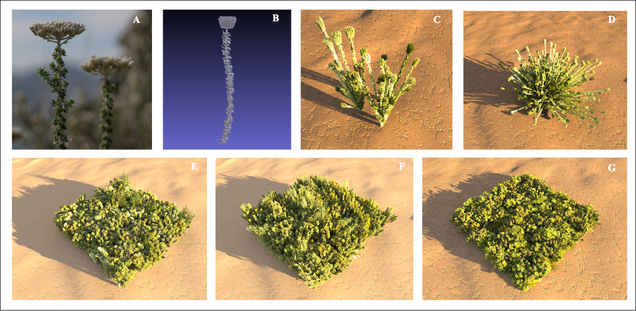
Figure 1: An illustration of how species are modeled, and scenes are generated for DIRSIG simulations. (A) shows one of the species present in the region, Metalasia muricata (adapted from the Steenbok Nature Reserve Webpage) ; (B) shows its corresponding 3D model; (C) demonstrates instantiation representing low-density growth; (D) demonstrates instantiation at high density; and (E), (F), and (G) show how these species models are combined with field data to replicate multiple burn plots corresponding to the 2006, 2016, and 2019 burn years, respectively.
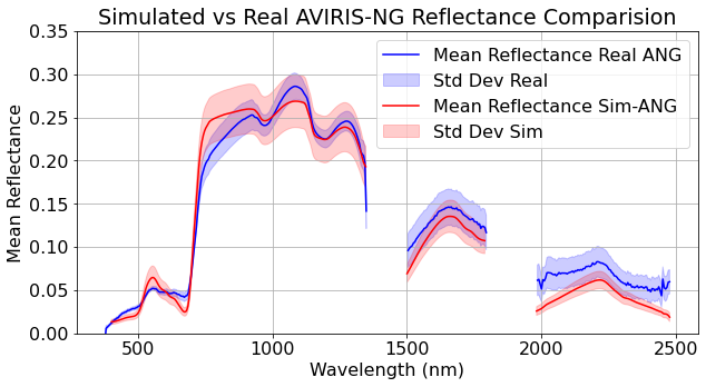
Figure 2: Simulated spectra are compared to real AVIRIS-NG spectra, showing strong visual agreement within ±1 standard deviation.
References
[1] Chaity, M. D., Eng, B., Irizarry, J., Saunders, G., Bhatta, R., and Aardt, J. v. Evaluating the influence of imaging spectrometer system specifications on ecosystem spectral diversity assessment. In AGU Fall Meeting Abstracts (2024), vol. 2024, pp. GC51CC–0032.
[2] Chaity, M. D., Slingsby, J., Moncrieff, G. R., Chancia, R. O., Bhatta, R., and Aardt, J. v. Enhancing mediterranean biodiversity monitoring in south africa via machine learning and cost-effective uas imagery. In AGU Fall Meeting Abstracts (2024), vol. 2024, pp. B11K–1455.
[3] Chaity, M. D., and van Aardt, J. Exploring the limits of species identification via a convolutional neural network in a complex forest scene through simulated imaging spectroscopy. Remote Sensing 16, 3 (2024), 498.
[4] Chaity, M. D., and van Aardt, J. A. Optimization of imaging spectrometer specifications for accurate vegetation species identification: A simulation-based approach using convolutional neural networks. In AGU Fall Meeting Abstracts (2023), vol. 2023, pp. B23L–07.