Satellite-derived land surface temperature (LST) split window algorithm development and validation
Principal Investigator(s)
Aaron Gerace
Research Team Members
Tania Kleynhans, Rehman Eon, Matthew Montanaro
Project Description
Several Split Window algorithms have been successfully applied to infrared satellite data (e.g. MODIS, VIIRS) for the estimation of land surface temperature. This research focuses on creating a Split Window algorithm for the Thermal Infrared Sensor (TIRS) onboard Landsat 8. Results are compared to the current Single Channel surface temperature method and 1518 in-situ validation sites. These sites include the SURFRAD and Ameriflux networks as well as ocean buoy measurements (NOAA) and Lake Tahoe and Salton sea buoys (JPL). Results of this study are provided to the Unit- ed States Geological Survey (USGS) to support their goals of releasing a validated land-surface temperature product to users.
Project Status:
Initial results show significant promise. The Split window algorithm is less resource intensive and does not rely on external data. The figure above shows the standard deviation of both the Single channel method and the Split Window method compared to the 1518 validation sites measurements, ordered by distance to nearest cloud. Ongoing work focuses on expanding the ground-based measurements used for comparison.
Figures and Images
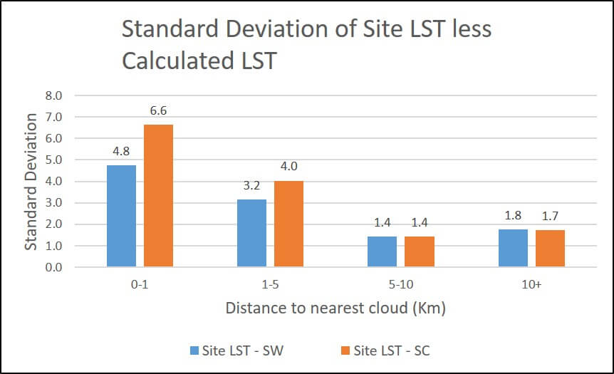
Comparison of ground-based measurements to retrieved surface temperature for two methodologies being considered by the United States Geological Survey.