On the Use of Terrestrial Laser Scanning for Structural Assessment of Complex Forest Environments
Principal Investigator(s)
Research Team Members
Rob Chancia
Richard Mackenzie (USFS)
Fei Zhang
Masasinge Hideos (RIT ENVS)
Ali Rouzbeh Kargar (Alumnus)
Sponsor:
United States Forest Service (USFS)
Project Description
Mangrove forests attempt to maintain their forest floor elevation through root growth, sedimentation, resistance to soil compaction, and peat development in response to sea level rise. Human activities, such as altered hydrology, sedimentation rates, and deforestation, can hinder these natural processes. As a result, there have been increased efforts to monitor surface elevation change in mangrove forests. Terrestrial lidar system (TLS) data were collected from mangrove forests in Micronesia in 2017 and 2019, using the Compact Biomass Lidar (CBL), developed by scientists at the University of Massachusetts (Boston) and RIT. Sediment accretion was assessed using the lidar data, using Cloth Simulation Filtering (CSF), followed by filtering the points based on angular orientation, which improved the performance of the ground detection. The elevation change between the two years was found by subtracting the Z (height) values of the nearest points, detected using a nearest neighbor search. Extreme elevation changes, attributed to human interactions or fallen logs, were removed using interquartile range analysis. The consistency of TLS-measured elevation changes in comparison to the field-measured ones was found to be 72%, with standard error values being 10-70x lower.
In March and April of 2024 Jan and Rob traveled to the Republic of Palau in Micronesia to conduct mangrove fieldwork with Richard Mackenzie of the US Forest Service. While in Palau, we obtained surface elevation table (SET) measurements at 17 different SET locations across the island of Babeldaob. The measurements included the traditional pin method, TLS method, and the new iPhone LiDAR method. The campaign served as the first mangrove trial of the iPhone LiDAR method, giving us a base dataset to repurpose our TLS processing framework. We implemented our scan processing and data storage into a web application at https://iphone-lidar-dem-builder.streamlit.app (Figure 1). The web application allows for uploading new scans to an AWS storage bucket, generation of a digital elevation model, and display of the 3D Gaussian splat model generated by the scan. We are implementing a GIS database to store elevation measures over time with respect to their SET measurement location and an image gallery.
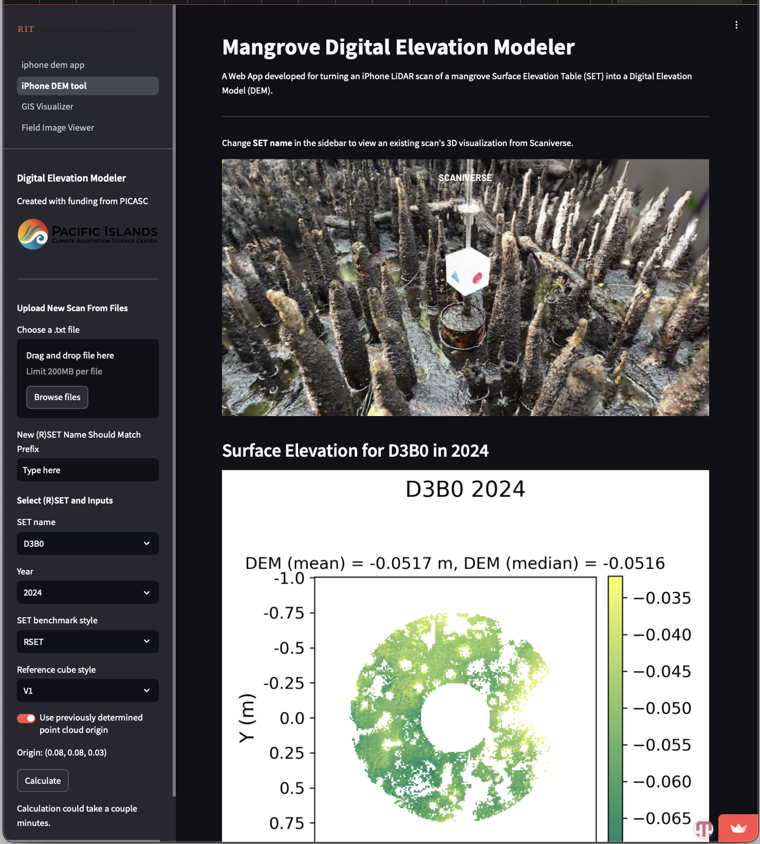
Figure 1: An example scan processed with the iPhone LiDAR DEM Builder web application.
During the Palau field trip we recruited a Palauan student who started at RIT in the fall of 2024. They are pursuing a Master's Degree in the Environmental Science Department, but will work on the project to investigate potential causes of extreme elevation changes at SET sites on Palau by investigating land use change in the upstream watersheds feeding into the SET sites.
References
[1] Chancia, R. O., van Aardt, J. A., and MacKenzie, R. A. Enhanced surface elevation change assessment in mangrove forests using a lightweight, low-cost, and rapid-scanning terrestrial lidar. In AGU Fall Meeting Abstracts (2023), vol. 2023, pp. EP31C–2085.
[2] MacKenzie, R. A., Krauss, K. W., Cormier, N., Eperiam, E., van Aardt, J., Kargar, A. R., Grow, J., and Klump, J. V. Relative effectiveness of a radionuclide (210pb), surface elevation table (set), and lidar at monitoring mangrove forest surface elevation change. Estuaries and Coasts 47, 7 (2024), 2080–2092.
[3] Rouzbeh Kargar, A., MacKenzie, R., Asner, G. P., and van Aardt, J. A density-based approach for leaf area index assessment in a complex forest environment using a terrestrial laser scanner. Remote Sensing 11, 15 (2019), 1791.
[4] Rouzbeh Kargar, A., MacKenzie, R. A., Apwong, M., Hughes, E., and van Aardt, J. Stem and root assessment in mangrove forests using a low-cost, rapid-scan terrestrial laser scanner. Wetlands Ecology and Management 28, 6 (2020), 883–900.
[5] Rouzbeh Kargar, A., MacKenzie, R. A., Fafard, A., Krauss, K. W., and van Aardt, J. Surface elevation change evaluation in mangrove forests using a low-cost, rapid-scan terrestrial laser scanner. Limnology and Oceanography: Methods 19, 1 (2021), 8–20