Using NOAA buoys to support calibration of Landsat’s thermal archive
Principal Investigator(s)
Aaron Gerace
Research Team Members
Nina Raqueño, Tania Kleynhans, Benjamin Kleynhans
Project Description
RIT has been a major participant in calibrating Landsat’s thermal archive for over twenty years. In this work, a forward modeling process has been developed and refined to make accurate estimates of band-effective radiance for the thermal instruments onboard Landsat 4, 5, 7, and 8. This model ingests temperature measurements obtained from the National Oceanic and Atmospheric Administration (NOAA) buoys as well as local radiosonde data to describe the environmental conditions of the pixel of interest during a Landsat overpass. These modeled data can serve as reference to characterize the behavior of the instruments over their lifetime. The figure below shows the locations of the buoys used to support this effort (left) and a characterization of the two thermal bands onboard Landsat 8 (right) that was developed using the model.
Project Status:
Calibration support to the Landsat Calibration & Validation Team using NOAA buoys is ongoing. Although the existing workflow is robust, future modification will focus
on ingesting reanalysis data into this automated process to increase the fidelity of reference estimates.
Figures and Images
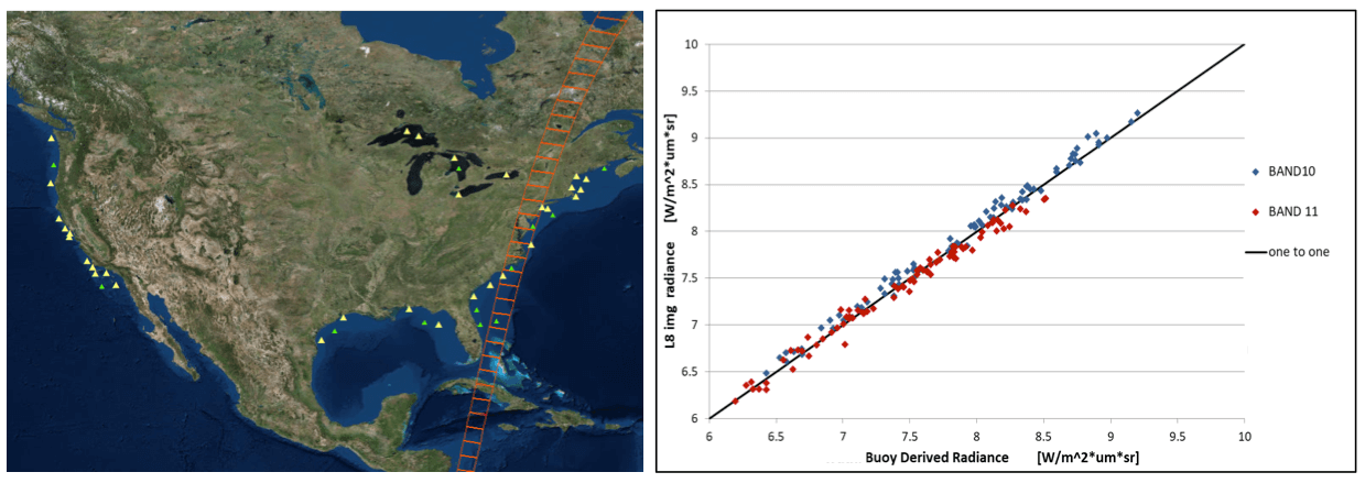
Illustration of NOAA buoy locations (left) used in a forwarding modeling process to provide calibration support to the Landsat Calibration & Validation Team. (Right) shows a comparison of modeled vs. observed radiance for the two thermal bands of Landsat 8.