A Comprehensive Approach Towards Enhancing Calibration, Validation, and Uncertainty Characterization of the Landsat Sensors and Archived Data
Principal Investigator(s)
Research Team Members
Amir Hassanzadeh
Rehman Eon
Matthew Montanaro
Elphas Khata
Project Description
This follow-on effort leverages and improves upon previous methodologies developed at RIT to ensure proper calibration of Landsat's active thermal sensors and validation of the archived higher-level surface temperature (ST) products. An automated workflow has been developed that leverages measurements from NOAA's buoy network, GEOS-5 reanalysis data and forward-modeling to better support calibration of Landsat's thermal sensors. The data created by this workflow are freely available to interested users at https://www.rit.edu/dirs/resources/landsat-thermal-validation. Calibration and validation results of this research effort are presented semi-annually at Landsat Calibration & Validation meetings.
Algorithm development represents a significant component of this five-year effort to support improved Landsat science. For example, estimation of (atmospheric) total precipitable water is an important component in characterizing the uncertainty associated with surface temperature (ST) retrieval algorithms. Considering the proposed band-combination for the Landsat Next Instrument Suite (LandIS) sensors, an algorithm for deriving TPW is being developed that will be used in the creation of LandIS per-pixel uncertainty maps to compliment future ST products derived using the TES (Temperature/Emissivity Separation) algorithm. Figure 1 illustrates the modeled relationship (first developed by Kaufman and Gao, 1992*) between the ratio of apparent reflectances in near-infrared bands and TPW, for LandIS. An algorithm that leverages machine-learning to derive TPW for Landsat's existing dual-channel thermal instruments has also been developed. This methodology uses an XGBoost decision-tree approach that relates Landsat's two thermal channels to the MODIS TPW product. Figure 2-right shows the result of this methodology when applied to Landsat 9 image data. Future work focuses on developing a workflow for estimating TPW using Landsat's single-channel instruments and characterizing the uncertainties associated with these TPW workflows.
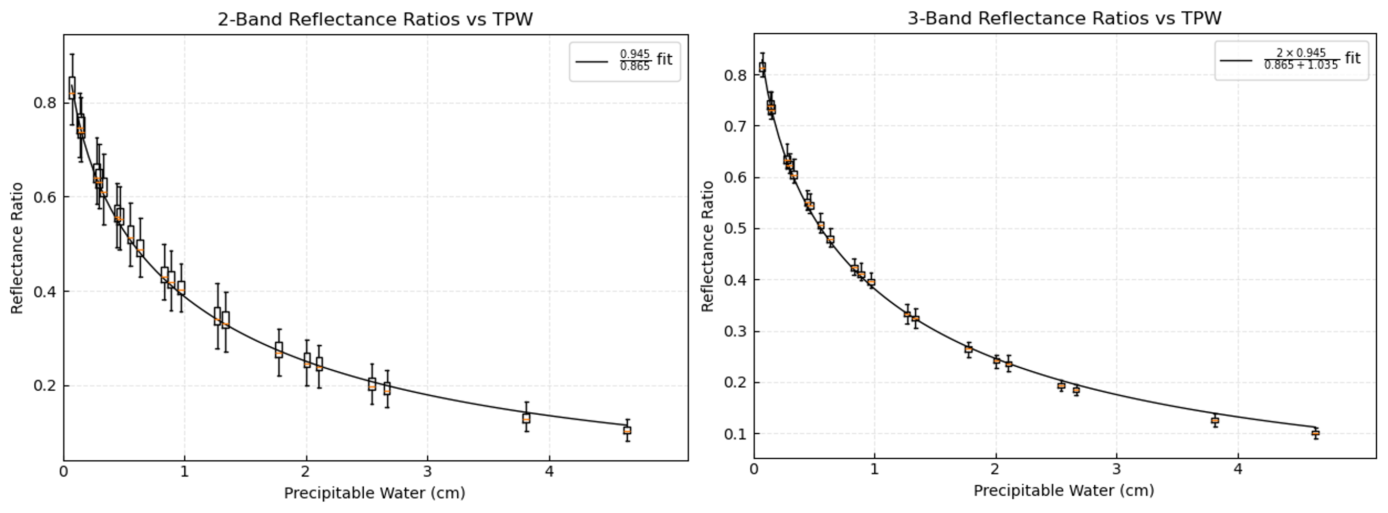
Figure 1: Modeled relationship of the ratio of apparent reflectances versus total precipitable water (TPW) for two channels (left) and three channels (right) in the near-infrared. This relationship was modeled after work conducted by Kaufman and Gao for the MODIS sensors.
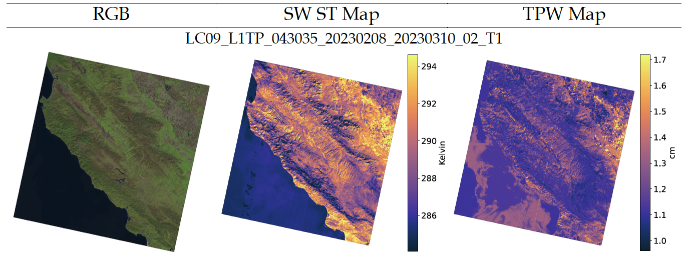
Figure 2: Illustration of the application of the XGBoost algorithm for deriving TPW for Landsat's dual-channel thermal infrared sensors. (Left) shows a true-color image for reference, (middle) the surface temperature map derived using a split-window algorithm developed at RIT, and (right) the corresponding TPW product derived using machine-learning. A mechanism to characterize per-pixel uncertainty to compliment the (middle) ST map is being developed and will use this TPW product (right).