Professor appointed to Landsat science team
John Schott will develop tools for monitoring fresh and coastal water
Pamela Schott
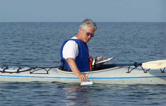
RIT imaging scientist John Schott is a key figure in the design and deployment of the Landsat series of satellites, the largest source of global remote sensing data. In the above picture, Schott measures water temperature on Lake Erie.
Rochester Institute of Technology scientist John Schott has been named to the Landsat Science Team by the U.S. Geological Survey, in cooperation with NASA.
Schott joins an expert team of scientists and engineers that will serve five years and provide technical and scientific support of the upcoming Landsat 8 spacecraft to be launched in February 2013. He will give input on issues pertaining to the use of satellite data for monitoring fresh and coastal waters.
“We hope that the new Landsat instrument will allow us, for the first time, to accurately map and monitor water quality conditions in the complex waters found in the coastal and fresh water environment,” says Schott, the Frederick and Anna B. Wiedman Professor in Imaging Science in RIT’s Chester F. Carlson Center for Imaging Science.
A succession of Landsat satellites has orbited the Earth’s poles since 1972. Each one has passed over the same spot every 16 days to construct cloud-free composite images used to detect and monitor global changes to the landscape.
Schott’s history with the program began in 1981, with a grant from NASA to work on Landsat 4. It was RIT's first major research grant and laid the cornerstone for the university’s imaging science program.
Topics
Recommended News
-
April 18, 2024
!['Sandra Johnson, Ritchie the Tiger, and Jackie Nicholson stand under a tent with shovels that are covered in dirt signifying a groundbreaking.']()
RIT community gathers to break ground on Tiger Stadium
RIT breaks ground on Tiger Stadium, a $30 million project set to redefine the university's athletic landscape. Scheduled for completion in fall 2025, the stadium serves as a new home to the lacrosse teams and will elevate attendee and student-athlete experiences.
-
April 18, 2024
!['a headshot of Andre Hudson appears in a circle to the left on a blue background. To the right appears the AAAS logo and the words Associate Fellow with Andres name and title.']()
André Hudson named AAAS fellow
RIT College of Science Dean André Hudson has been named a fellow of the American Association for the Advancement of Science (AAAS), as announced by the organization’s council.
-
April 18, 2024
!['an arial view of Croatia’s Neretva Delta is shown through clouds with birds in the air.']()
RIT Global students set to present at Imagine RIT
Students from RIT’s global campuses will be making the trek to the U.S. for this year’s Imagine RIT: Creativity and Innovation Festival. Teams from all of RIT's global campuses will be presenting their exhibits in the Gordon Field House; this is the second year that students from global campuses will be attending the festival in person.
-
April 18, 2024
!['a headshot of Alireza Vahid appears on the right with his name, title, and department to the left.']()
Engineering professor becomes part of SMART Hub to improve wireless spectrum accessibility
The wireless spectrum has become very crowded real estate, and work is underway through a new technology research center to improve spectrum access, co-existence, and security.