Michael Denning ’07, remote sensing scientist, Integrity Applications Incorporated
Integrity Applications Incorporated
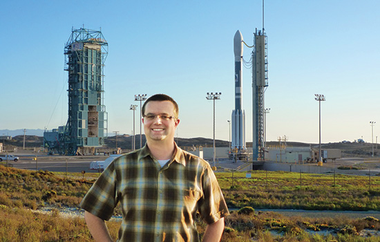
Michael Denning ’07 oversees the development of satellite systems built for the U.S. National Oceanic and Atmospheric Administration and NASA. This photo was taken at Vandenberg Air Force Base in California, shortly before the launch of a Delta II rocket that carried an environmental satellite into orbit on Oct. 28, 2011.
He may not be able to control Mother Nature, but Michael Denning is helping to create the systems that record her most changeable weather patterns.
Denning ’07 (imaging science) is a senior system engineer and remote sensing scientist at Integrity Applications Incorporated, a private engineering and software services company based in Virginia with contracts primarily supporting the aerospace needs of government agencies. One of his first projects was overseeing the development, launch and operations of a satellite for NASA and the U.S. National Oceanic and Atmospheric Administration (NOAA).
“The Joint Polar Satellite System is our nation’s most advanced polar-orbiting environmental satellite system and is one of two major programs that provides the government with data for improving short-term weather forecasts and monitoring long-term climate change,” he said.
Denning, who began work on the project in 2007, provided cross-agency programmatic and technical support and was able to see firsthand the entire lifecycle of a satellite program from its initial development to routine operations to production of end user products. “And the launch was exciting even though it took place at 3 a.m.,” he said, laughing.
“We were in California watching the rocket fly into orbit. After a few minutes it was just another star, and then a few minutes later it was out of sight completely. It was a great experience knowing that you helped the mission succeed, that you contributed to something that would be orbiting the Earth 14 times a day at 500 miles over our heads for years to come.”
In October 2014, Denning transitioned to a new project for the White House Office of Science and Technology Policy. While his work with NASA and NOAA focused on one single satellite system, his newest role requires gathering information about hundreds of Earth-observing systems and evaluating the impact of those systems. The work brings together many government agencies, corporations and academic researchers, and culminates with a report intended to help the government develop a strong national plan for the use of, and investment in, Earth-observing systems.
Denning, who was hired right after graduating from RIT’s imaging science program, said his undergraduate education gave him the context needed to excel in his jobs where rapidly integrating technical information from multiple sources and responding in intelligent ways was absolutely critical.
“The imaging science program is very unique, especially for an undergrad,” he said. “It is a field that pulls from many disciplines such as mathematics, physics, engineering, computer science and others with a focus on anything imaging-related, from printers to MRIs to satellites, for example. Students typically do not have an opportunity to study such a specialized field without getting a graduate degree. So as an undergraduate imaging science major, I was especially attractive to employers and well positioned to find meaningful work and go directly into industry upon graduation. Without my education at RIT, I would not be where I am today.”
Washington, D.C., is a hub for imaging science graduates who, like Denning, go into the government’s classified and civil sector programs. It is work that gives him a sense of meaning and purpose.
“It’s reassuring to know that your work has a positive impact on society, that these technologies and data are used to save lives and property and to advance our world in so many ways.”