Researcher develops new disaster response technology for United Nations
Virtual globe program used to visualize and analyze disaster management
Brian Tomaszewskii
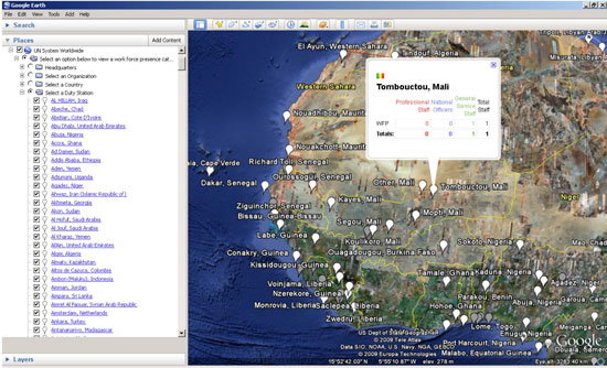
In these examples of U.N. Duty Stations in Western Africa, each white point represents where the U.N. has a presence. Viewers can click on the points to find out what U.N. organization is operating at a given location and how many people are working there.
Brian Tomaszewski, assistant professor in the Center for Multidisciplinary Studies, has taken the popular Google Earth virtual globe program, and connected it with one of the largest international workforce and service organizations—the United Nations. He has developed an interactive map of the entire U.N. system around the world for display in Google Earth, a collaborative effort between RIT and the United Nations Geographic Information Working Group.
With activities ranging anywhere from peacekeeping operations to studying the effects of climate change, to utilizing space-based technologies for disaster management, the U.N. has grown into a complex organization with extensive information needs.
Tomaszewski developed a computer program to take text-based information and translate it into map-based images, allowing U.N. leaders to see worldwide distribution of the U.N. system and activities.
“The U.N. system data is available, but there was a need for translating it into a different, easier-to-use format,” he says. He worked for over a year on the original design process, data input and application pilot before finally releasing a beta version a few months ago.
“The rich interactivity and visual interface of Google Earth is easy to use, therefore making this kind of information more accessible to a wider range of people,” he says. The U.N. system ‘layer’ was not the only U.N.-related work he has done using the automated mapping algorithms. Tomaszewski is currently in Bonn, Germany, working for three months to immerse himself in another of his geographic information science and technology projects for the U.N. Office of Outer Space Affairs, U.N. Platform for Space-based Information for Disaster Management and Emergency Response group, or UN-SPIDER. This group uses information from international satellite communication facilities to collate information about humanitarian and emergency response efforts.
“The basic research science of text transformation, sometimes called geographic information retrieval, or even geo-coding, can be applied to a lot of different application domains,” Tomaszewski explains. Results of his research with UN-SPIDER will eventually allow organizations besides the U.N. to have real-time, coordinated information to ensure adequate preparation prior to a disaster or in its aftermath.
Nathan Green, a fifth-year computer science major, joined Tomaszewski in Bonn for two weeks in April and worked on the beta version of disaster resource mapping tool called the Visual Globe. “This is intended as a visualization tool for people who would like to see search results geographically related,” says Green.
The Space Applications Matrix tool Green worked on allows quick access to the UN-SPIDER knowledge portal’s detailed information from preparedness levels to response and recovery status, he explains. The portal uses data from remote sensing and global satellite communication resources that highlight topical landscapes and weather phenomena over regions of the globe. The portal will also integrate the human factor, he says.