DIRS Annual Report 2025-2026

Foreword
As the 2025–2026 fiscal year comes to a close, the members of the Digital Imaging and Remote Sensing (DIRS) Laboratory reflect with pride on another year of innovation, discovery, education, and service. The accomplishments highlighted throughout this report are a testament to the dedication of our students, staff, faculty, collaborators, and alumni who continue to make DIRS an extraordinary community.
Education remains front and center for all of us at DIRS. This year, we continued expanding our curriculum with a new graduate course in synthetic aperture radar (SAR) developed and taught by Dr. James Albano. Dr. Albano also took the reins for the graduate "Fourier" class, a course that has long been a rite of passage for students in our graduate program. We also received approval for a minor in Remote Sensing for undergraduate students across the university. This minor will become active in the Fall semester of the 2026-2027 academic year.
It is always tremendous to see the generous contributions of our talented research staff and faculty, who bring their cutting-edge expertise into the classroom — a unique strength of DIRS. We are deeply grateful for their willingness to share their expertise, and I know our students will carry these experiences with them throughout their careers. It is one of the defining strengths of DIRS and one of the many reasons this laboratory continues to be such a special place to learn, teach, and conduct research.
While curriculum and research continue to evolve, our greatest source of pride is not the courses we create or the research we conduct—it is our students. Their curiosity, creativity, and willingness to tackle challenging problems continually inspire us. Whether conducting research in our laboratories, presenting at conferences, publishing scholarly work, or launching careers in industry, government, and academia, they embody the mission of DIRS and carry its impact far beyond our walls. Watching them grow into outstanding scientists, engineers, and leaders remains one of the greatest rewards of what we do.
This year we also bid farewell to an outstanding member of our research staff, Jeff Dank. Jeff's professionalism, technical expertise, and friendship have left a lasting mark on our laboratory. We are grateful for his many contributions to DIRS and wish him every success in the next chapter of his career.
As I say every year — and always mean — I am deeply grateful for the support we receive from the many individuals and offices across RIT that make our work possible. I want to especially thank:
- Denis Charlesworth and April Burns in Sponsored Research Services, who expertly guide us through every stage of the research lifecycle.
- Laura Girolamo, the Controller's Office, and Sponsored Program Accounting, who help us remain financially responsible, compliant, and effective stewards of sponsored research.
- Our Human Resources colleagues, who help ensure that DIRS continues to be a supportive and welcoming workplace.
All of these individuals — and many more I may have missed — are essential to the daily success of this laboratory, and I offer my sincere thanks to each of them.
I also extend my sincere appreciation to Dr. Jan van Aardt, Director of the Chester F. Carlson Center for Imaging Science, and Dr. André Hudson, Dean of the College of Science, for their steadfast support and encouragement. I am equally grateful to Dr. Ryne Raffaelle, Vice President for Research, for his strategic guidance and unwavering support of the laboratory, and to RIT President Dr. William Sanders and Provost Prabu David for their continued commitment to strengthening and elevating the university's research enterprise.
As with any research organization, we continue to adapt to an evolving research landscape and an ever-changing funding environment. These changes reinforce the importance of collaboration, innovation, and thoughtful stewardship of our resources. More importantly, they remind us that the true strength of DIRS has never been defined by a building or a budget, but by the remarkable people who make this laboratory what it is.
This year marks the beginning of DIRS' fifth decade of innovative research. Forty years have passed remarkably quickly, yet our mission has remained constant: to advance the science of imaging and remote sensing while educating the next generation of researchers, scientists, and engineers. It has been an extraordinary journey - one made possible by exceptional students, faculty, research staff, collaborators, alumni, and their families. Some members of our laboratory have been part of that journey since the laboratory's founding forty years ago, providing continuity, wisdom, and a deep appreciation for the traditions that define DIRS. As we look ahead, we remain committed to honoring that legacy while continuing to innovate and grow. The challenges before us are different than those of the 1980s, but the spirit that built this laboratory remains exactly the same.
Whether you are one of our alumni, a research collaborator, an industrial partner, or simply someone interested in the future of imaging and remote sensing, we welcome hearing from you. Your perspectives, ideas, and continued engagement help shape the future of DIRS. The fields of imaging science and remote sensing are evolving at an unprecedented pace, and we are committed to evolving with them—ensuring that DIRS continues to educate exceptional scientists and engineers while advancing research that serves society.
As I begin my 32nd year in the DIRS Laboratory, I continue to be humbled by the privilege of working alongside such extraordinary students, staff, faculty, collaborators, alumni, and friends. Thank you for being part of the DIRS family. I look forward to writing the next chapter of our story together.
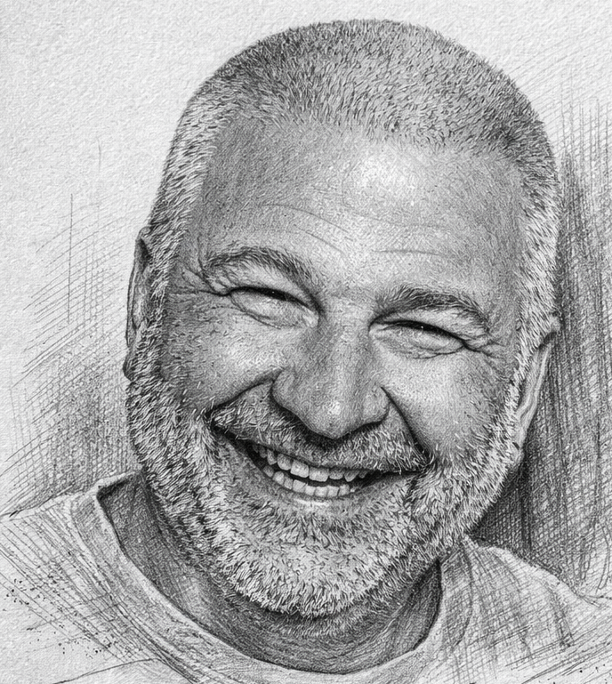
My warmest regards,
Carl Salvaggio
Director, Digital Imaging and Remote Sensing (DIRS) Laboratory
Chester F. Carlson Center for Imaging Science
Rochester Institute of Technology
Financial Reports
The DIRS financial reporting for FY26 is summarized below for both the sponsored research, enterprise center, and DIRSIGTM Alliance portions of the laboratory.
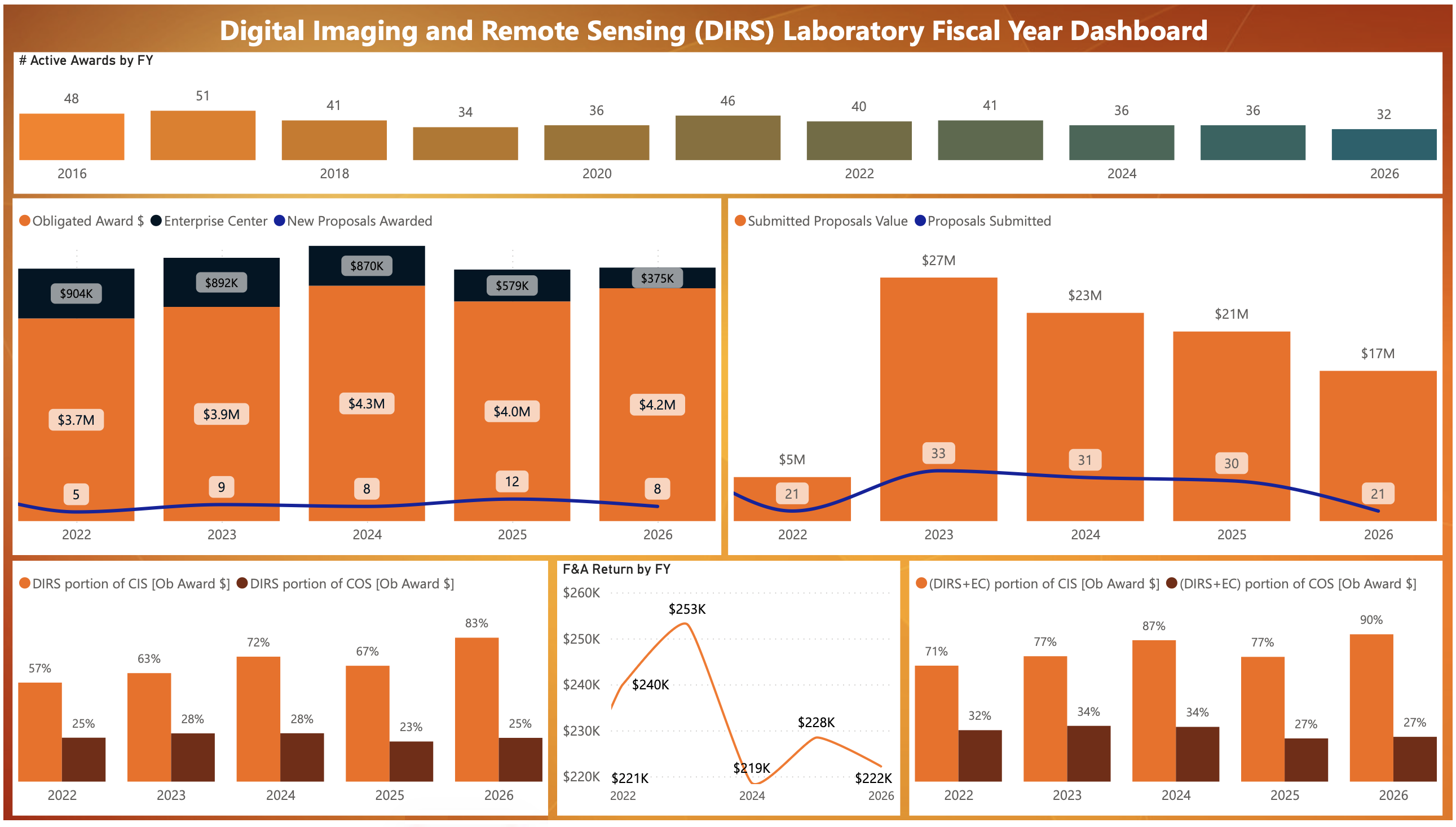
The Digital Imaging and Remote Sensing (DIRS) Laboratory maintained a strong and diversified research portfolio in FY26 despite a challenging federal funding environment. The laboratory had 32 active awards in FY26 continuing a multi-year portfolio of sponsored research and technology development programs. While active awards declined from recent peak years, DIRS sustained a robust project base and continued to generate significant research activity across government and industry sponsors.
Financial Performance
DIRS secured approximately $4.2M in obligated award funding during FY26, representing one of the strongest annual funding totals of the past five years and an increase from FY25. Enterprise Center-supported activities contributed an additional $375K, demonstrating continued success in leveraging multiple funding mechanisms to support laboratory growth.
The laboratory generated over $200K in Facilities and Administrative (F&A) return, providing important resources to support research faculty and staff efforts to secure new funding.
Proposal Development and Business Growth
DIRS remained highly active in pursuing new opportunities, submitting 21 proposals valued at approximately $17M during FY26. Although proposal volume and total value were lower than the previous three years, the submission portfolio remained substantial and reflects continued engagement with federal agencies, industry partners, and competitive research programs.
The laboratory achieved 8 new awards in FY26, consistent with FY24 performance and demonstrating continued competitiveness in a constrained funding environment.
College and Institute Contributions
DIRS continued to serve as a significant contributor to the Chester F. Carlson Center for Imaging Science (CIS) research mission:
- DIRS accounted for approximately 83% of CIS obligated award funding in FY26.
- When Enterprise Center activity is included, DIRS represented approximately 90% of CIS's total sponsored funding portfolio, underscoring the laboratory's central role in the CIS research enterprise.
DIRS also contributed significantly to the university's overall research performance:
- DIRS generated approximately 25% of the College of Science (COS) sponsored research funding, both with and without Enterprise Center activity included.
Strategic Observations
Several important trends emerged during FY26:
- Award funding remained strong, with FY26 obligated funding exceeding FY25 levels and approaching the laboratory's highest recent annual totals.
- Proposal activity moderated compared to FY23-FY25, reflecting increased competition and reduced federal research spending across several agencies.
- Research impact within CIS continued to grow, with DIRS representing a larger share of the Center’s sponsored research portfolio than in previous years.
FY26 Overall Assessment and FY27 Outlook
While FY26 remained a productive year for the DIRS Laboratory, the underlying indicators point to a more challenging outlook for FY27 and beyond. DIRS maintained strong obligated funding levels, secured eight new awards, and continued to serve as the primary driver of sponsored research activity within the Center for Imaging Science. However, the laboratory experienced a notable decline in proposal submissions and total proposal value, with proposal activity decreasing from 30 proposals valued at $21M in FY25 to 21 proposals valued at $17M in FY26.
Much of this decline can be attributed to the uncertainty surrounding the U.S. federal research funding landscape throughout FY26. Ongoing political disputes, delayed appropriations, shifting agency priorities, and the potential for federal budget reductions created significant hesitation across the research community, resulting in fewer funding opportunities, delayed solicitations, and extended award timelines. Because the DIRS Laboratory relies heavily on federally sponsored research programs, these external factors have increased risk to future revenue streams and portfolio growth.
Although FY26 funding performance remained strong due to awards secured in prior years and the continued execution of existing projects, the reduction in proposal activity creates a smaller pipeline of opportunities from which future awards can be generated. As a result, FY27 may experience increased financial pressure as current projects conclude and competition for available funding intensifies. The laboratory will continue to aggressively pursue new opportunities, diversify its funding portfolio, expand industry partnerships through the DIRS Enterprise Center, and strengthen collaborations across government, academia, and industry. Nevertheless, absent of an improvement in the federal research funding environment, DIRS anticipates a more constrained and uncertain fiscal outlook in FY27, requiring careful management of staffing, resources, and strategic investments to maintain long-term growth and sustainability.
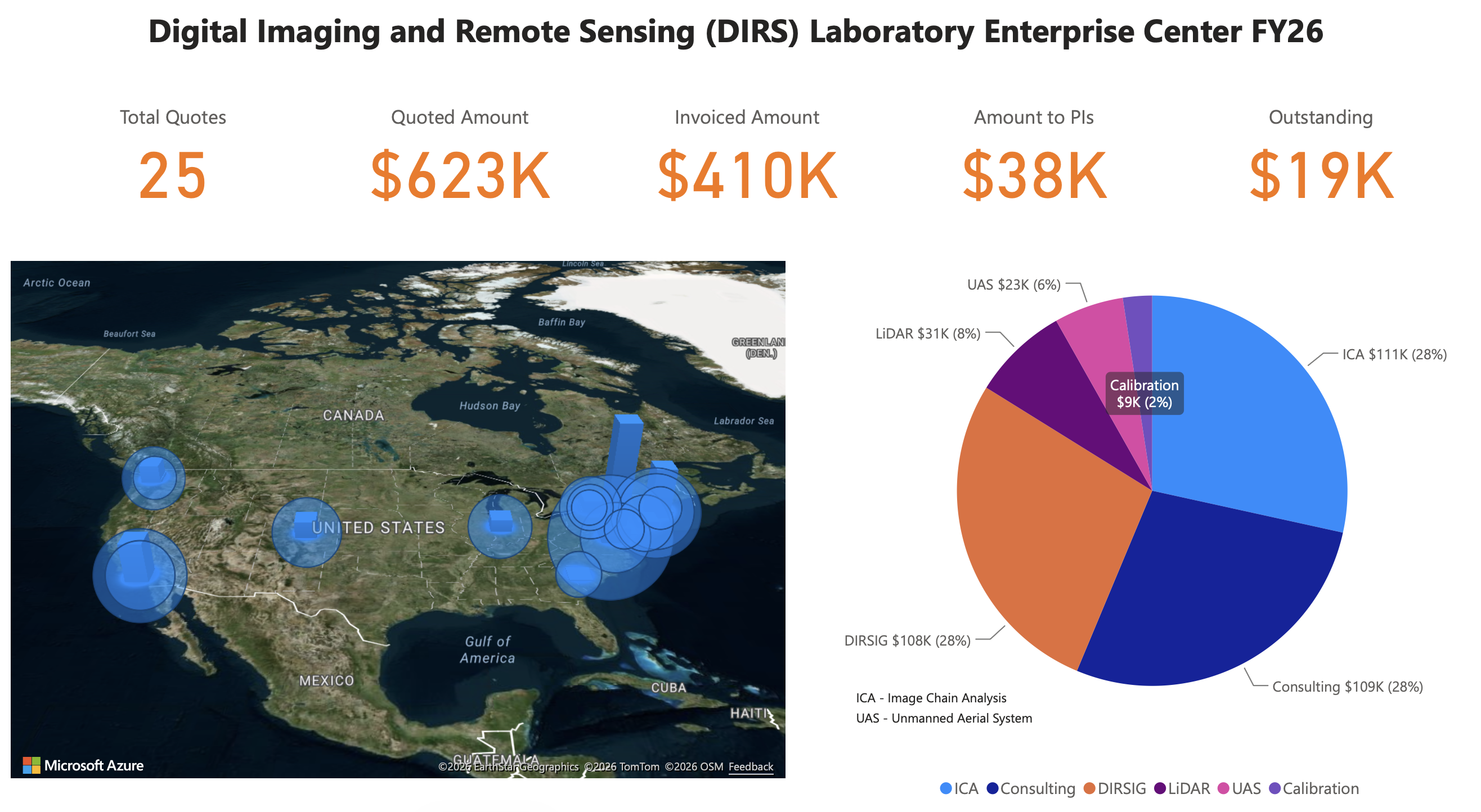
Since 2019, the Digital Imaging and Remote Sensing (DIRS) Laboratory has expanded its impact beyond sponsored research through the DIRS Enterprise Center (EC), providing specialized fee-for-service capabilities to industry and academic partners. Leveraging the laboratory's extensive expertise in unmanned aerial systems (UAS), sensor/radiometric calibration, imaging science, modeling and simulation, and remote sensing, the Enterprise Center delivers professional services including training, technical consulting, data collection, sensor characterization and calibration, analytical support, and customized project solutions.
As one of RIT's Enterprise Centers, the DIRS EC operates as a fee-for-service organization, enabling external partners to access the unique capabilities of DIRS faculty and staff while fostering new collaborations and technology applications. The Enterprise Center continues to support a diverse range of industries and organizations by providing high-quality data, technical expertise, and innovative solutions that address complex imaging and remote sensing challenges. DIRS remains committed to expanding its external partnerships and delivering exceptional service that advances both client objectives and RIT's mission of research, innovation, and community engagement.
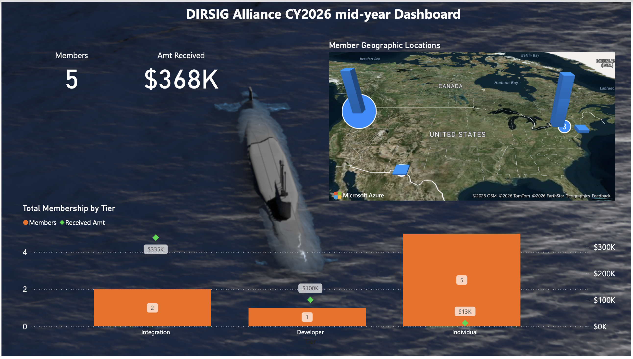
In early 2026, we launched the "DIRSIGTM Alliance" which is membership-based community created to support the support the long-term health, growth, and innovation of the DIRSIGTM physics-based remote sensing simulation software. For 30+ years the software and updates to that software has been freely available to our user community without annual software subscriptions that are common for similar science and engineering software products. Unfortunately, the DIRSIGTM team is not directly funded by the university and revenue opportunities that had historically been used to fund the team that develops the software have become less common. Although we will still pursue open calls and collaboration with companies, labs and organizations, these opportunities are generally targeted at specific capabilities and do not provide the resources required to maintain and generally improve the model for a large and diverse user community. Rather than spin the software off as a commercial product with hefty annual subscription costs to the users, we went a different route with an optional membership model that rewards users that support the tool with special privileges while maintaining a free version of the software for other users. Hence, the Alliance allows organizations that rely on DIRSIGTM for important engineering and research functions to fund the day-to-day maintenance of the software and to have a hand in the advancement of the software. At the time of this writing, we are only 6 months into this supplemental funding experiment. In addition to individual users opting into our membership program, we brought on several partner organizations that are developing advanced capabilities that leverage the DIRSIGTM software.
Revenue from our Alliance memberships has already been used to address several tech debt related activities. This includes a rewrite of our web-based software distribution portal and updates to our continuous integration and continuous deployment (CI/CD) environment. We currently have several advanced technology projects underway that will be available to our Alliance user community this fall. This includes the development of automated, geo-spatial centric workflows for creating large-area coverage, hierarchical level-of-detail (HLOD) scenes. We are also working on a powerful, new subsystem that supports the definition of arbitrary material descriptions using a spectral extension of NVIDIA’s Material Definition Language (MDL), which is one of the cornerstone technologies of their OmniVerse platform. And finally, we are experimenting with how to create and deliver high-quality, asynchronous training content for new users and advanced training for existing users as part of an effort to make the software more accessible.
To learn more about the DIRSIGTM Alliance and the benefits available at the various membership tiers, visit the webpage.
Publications
Bachmann, C. M., Nur, N. B., Tyler, A. C., Owens-Rios, W. A., Goldsmith, S., Bauch, T. D., and Luby, A., “Mapping marine invertebrate populations in coastal salt marsh ecosystems using hyperspectral imagery,” in AGU Fall Meeting Abstracts, 2025, GC24A–03 (2025). URL: https://agu.confex.com/agu/agu25/meetingapp.cgi/Paper/1917277.
Baur, J., Lekhak, S., Steinberg, G., Nikulin, A., Smet, T. d., Brinkley, A., Ientilucci, E. J., Nitsche, F., Myers, H., Elliott, J., et al., “A comparative evaluation of uav-based remote sensing and geophysical techniques for landmine detection on a seeded minefield,” Remote Sensing 18(13), 2182 (2026). https://doi.org/doi.org/10.3390/rs18132182.
Bhatta, R., Chaity, M. D., Chancia, R. O., Slingsby, J., Moncrieff, G., and van Aardt, J., “Assessment of structural differences in a low-stature Mediterranean-type shrubland using structure-from-motion (SfM),” Remote Sensing 17(16), 2784 (2025). https://doi.org/10.3390/rs17162784.
Bhatta, R., Chaity, M. D., and van Aardt, J., “A novel data-driven approach to leaf area index modeling using high-fidelity simulation-based full-waveform LiDAR data,” IEEE Journal of Selected Topics in Applied Earth Observations and Remote Sensing 19, 4693–4716 (jan 2026). https://doi.org/10.1109/jstars.2026.3652921.
Brown, S. and Kerekes, J. P., “Synthesis of Earth observation imagery,” GeoAI for Earth Observation Imagery , 223–256 (2026). https://doi.org/10.1016/b978-0-44-343796-0.00019-x.
Burglewski, N., Srinivasagan, S. N., Ketterings, Q. M., and van Aardt, J., “Analysis of the temporal evolution of the spectral and spatial sensitivities of a support vector regression maize yield algorithm,” Computers and Electronics in Agriculture 239, 110930 (2025). https://doi.org/10.1016/j.compag.2025.110930.
Chaity, M. D., Slingsby, J. A., Moncrieff, G. R., Chancia, R. O., Bhatta, R., and van Aardt, J., “Advancing Mediterranean biodiversity monitoring in South Africa through machine learning and cost-effective UAS imagery,” Journal of Geophysical Research: Biogeosciences 131 (jan 2026). https://doi.org/10.1029/2025jg009096.
Clapp, J. G., Eng, B. K., and Salvaggio, C., “Automatic registration of subsea LiDAR point clouds,” in Electronic Imaging 2026: Autonomous Vehicles and Machines, Electronic Imaging 38, 103–1–103–11, Society for Imaging Science and Technology (mar 2026). https://doi.org/10.2352/ei.2026.38.16.avm-103.
Denton, J. C. and Albano, J. A., “Passive sensing and image formation via Starlink downlink,” Algorithms for Synthetic Aperture Radar Imagery XXXII 13456, 52 (2025). https://doi.org/10.1117/12.3052649.
Elinisa, C. A., Wa Maina, C., Vodacek, A., and Mduma, N., “Image segmentation deep learning model for early detection of banana diseases,” Applied Artificial Intelligence 39(1), 2440837 (2025). https://doi.org/10.1080/08839514.2024.2440837.
Eon, R., Gerace, A., and Montanaro, M., “A forward modeling approach for the vicarious validation of the thermal infrared sensor on-board Landsat 8 and 9,” IEEE Journal of Selected Topics in Applied Earth Observations and Remote Sensing 19, 9020–9031 (jan 2026). Complete author list and pagination should be imported from IEEE Xplore. https://doi.org/10.1109/jstars.2026.3670640.
Eon, R. S., De Groot, C., Pedelty, J. A., Gerace, A., Montanaro, M., Covington, R. K., DeLisa, A. S., Hsieh, W.-T., Henegar-leon, J. M., Daniels, D. J., et al., “Toward a near-lossless image compression strategy for the NASA/USGS Landsat Next mission,” Remote Sensing of Environment 329, 114929 (2025). https://doi.org/10.1016/j.rse.2025.114929.
Eon, R. S., Gartley, M. G., Holmes, T. R. H., Gerace, A., Montanaro, M., Serbin, S., and Cook, B. D., “Modeling polarimetric effects on aquatic remote sensing retrievals for Landsat 10,” Optical Engineering 65, 073101 (jul 2026). https://doi.org/10.1117/1.OE.65.7.073101.
Evans, J., Eon, R., Montanaro, M., and Gerace, A., “An independent software implementation of the CCSDS 123.0-B-2 compression standard for the Landsat Next mission,” in Algorithms, Technologies, and Applications for Multispectral and Hyperspectral Imaging XXXII, Algorithms, Technologies, and Applications for Multispectral and Hyperspectral Imaging XXXII 14025, 26, SPIE, SPIE (2026). https://doi.org/10.1117/12.3092785.
Gartley, M. G., “Prediction and image formation for serendipitous resident space object underflights of Landsat 8,” IEEE Journal of Selected Topics in Applied Earth Observations and Remote Sensing 19, 7534–7542 (jan 2026). Verify whether the final IEEE record contains additional authors. https://doi.org/10.1109/jstars.2026.3663996.
Hao, Y., Mao, J., Bachmann, C. M., Hoffman, F. M., Koren, G., Chen, H., Tian, H., Liu, J., Tao, J., Tang, J., et al., “Soil moisture controls over carbon sequestration and greenhouse gas emissions: A review,” npj Climate and Atmospheric Science 8(1), 16 (2025). https://doi.org/10.1038/s41612-024-00888-8.
Hassanzadeh, A., Krawczyk, B., Saunders, M., Wible, R., Krause, K., Dera, D., and Van Aardt, J., “Deep imbalanced multi-target regression: 3D point cloud voxel content estimation in simulated forests,” IEEE Transactions on Geoscience and Remote Sensing , 1–1 (2026). https://doi.org/10.1109/tgrs.2026.3713799.
Kaplan, H., Simon, A., Reuter, D., Emery, J., Howett, C., Grundy, W., Sunshine, J., Protopapa, S., Lunsford, A., Montanaro, M., et al., “An overview of Lucy L’Ralph observations at (52246) Donaldjohanson and (152830) Dinkinesh: Visible and near-infrared data of two main belt asteroids,” EPSC-DPS2025 (EPSC-DPS2025-731) (2025). https://doi.org/10.5194/epsc-dps2025-731.
Kazeneza, M., Bosman, A. S., Amenyedzi, D. K., Hanyurwimfura, D., Ndashimye, E., and Vodacek, A., “Balancing complexity and performance of machine learning models for avian pests sound detection in agricultural environments,” IEEE Access 13 (2025). https://doi.org/10.1109/access.2025.3580620.
Kazeneza, M., Bosman, A. S., Amenyedzi, D. K., Niyongabire, P., Ndashimye, E., Hanyurwimfura, D., and Vodacek, A., “Lightweight deep learning model for real-time acoustic bird pest detection on edge microcontrollers,” PeerJ Computer Science 12, e3925 (2026). https://doi.org/10.7717/peerj-cs.3925.
Kerekes, J. P., Raqueno, N. G., and Riley, D. N., “Rochester Institute of Technology’s Open Community eXperimenti (rocx) 2025,” IEEE Geoscience and Remote Sensing Magazine 14(2), 139–143 (2026). https://doi.org/10.1109/mgrs.2026.3651412.
Kerekes, J. P. and Raqueno, N. G., “ROCX 2025: Planning and execution of a major community remote sensing data collection,” Algorithms, Technologies, and Applications for Multispectral and Hyperspectral Imaging XXXII , 6 (2026). https://doi.org/10.1117/12.3094981.
Khata, E. M., Gerace, A., Hassanzadeh, A., and Eon, R. S., “A proposed algorithm for retrieving total precipitable water from Landsat Next instrument suite,” Algorithms, Technologies, and Applications for Multispectral and Hyperspectral Imaging XXXII 14025, 19 (2026). https://doi.org/10.1117/12.3100728.
Landis, G. A., Oleson, S. R., Fox, A. C., Polly, S., and Chancia, R., “Design of a smallsat for Uranus,” ASCEND 2026 (2026). https://doi.org/10.2514/6.2026-3011.
Lee, C. H., Bachmann, C. M., Nur, N. B., Union, K. E., Lapszynski, C. S., and Shiltz, D. J., “Coordinating high-resolution hyperspectral and RGB video acquisition of dynamic natural water scenes,” Journal of Applied Remote Sensing 19(2), 024507–024507 (2025). https://doi.org/10.1117/1.jrs.19.024507.
Lekhak, S., Ientilucci, E. J., Baur, J., and Ghosh, S., “A UAV-based vnir hyperspectral benchmark dataset for landmine and UXO detection,” 2025 IEEE India Geoscience and Remote Sensing Symposium (InGARSS) , 990–994 (2025). https://doi.org/10.1109/ingarss67683.2025.11583810.
Lekhak, S., Ientilucci, E. J., Dera, D., and Ghosh, S., “Uncertainty quantification in surface landmines and UXO classification using MC dropout,” IGARSS 2025 - 2025 IEEE International Geoscience and Remote Sensing Symposium , 1177–1181 (2025). https://doi.org/10.1109/igarss55030.2025.11243138.
Liu, X., Xu, A., Cao, W., and Ientilucci, E., “Structure-aware representation distillation for tiny-dense object segmentation,” in Proceedings of the IEEE/CVF Conference on Computer Vision and Pattern Recognition, 34775–34783 (2026). URL: https://openaccess.thecvf.com/content/CVPR2026/html/Liu_Structure-Aware….
Lo, E. and Ientilucci, E. J., “A neural network algorithm with three hidden layers for subpixel target detection,” IGARSS 2025 - 2025 IEEE International Geoscience and Remote Sensing Symposium , 8941–8945 (2025). https://doi.org/10.1109/igarss55030.2025.11243823.
Macalintal, J. N. G. M. and Messinger, D. W., “Custom pigment targets for evaluating VNIR-SWIR hyperspectral sharpening algorithms,” (2026). https://doi.org/10.1117/12.3092723.
Mao, D. and Albano, J., “Aspect dependent phase error of rotating targets in SAR imagery,” in 2025 IEEE International Radar Conference (RADAR), 1–6, IEEE (2025). https://doi.org/10.1109/radar52380.2025.11031566.
Marchi, S., Levison, H. F., Noll, K. S., Spencer, J. R., Statler, T. S., Barnouin, O. S., Bell III, J. F., Bierhaus, E. B., Binzel, R., Bottke, W. F., et al., “The Lucy flyby of (52246) Donaldjohanson: A bilobed asteroid with tumbling rotation,” Science 392(6804), 1287–1291 (2026). https://doi.org/10.1126/science.aec0503.
Mason, G. J. and Albano, J. A., “Moving target detection with colorized subaperture imagery,” Algorithms for Synthetic Aperture Radar Imagery XXXIII 14026, 11 (2026). https://doi.org/10.1117/12.3094658.
Nur, N. B., Thompson, D. R., Brodrick, P., Turmon, M., Carmon, N., Bachmann, C. M., Green, R. O., and Keebler, A., “Mapping surface soil moisture from EMIT hyperspectral observations via physically-based inversion,” in AGU Fall Meeting Abstracts, 2025, GC31F–0747 (2025). URL: https://agu.confex.com/agu/agu25/meetingapp.cgi/Paper/1973412.
Nur, N. B., Carmon, N., Thompson, D. R., Brodrick, P., Bachmann, C. M., and Green, R. O., “Mapping vegetation fuel properties using EMIT hyperspectral time series and PROSAIL for wildfire risk assessment,” in AGU Fall Meeting Abstracts, 2025, B23B–04 (2025). URL: https://agu.confex.com/agu/agu25/meetingapp.cgi/Paper/1973451.
Nur, N. B., Bachmann, C. M., Brodrick, P. G., Carmon, N., Green, R. O., and Thompson, D. R., “Soil moisture estimation and mapping using radiative transfer models and EMIT hyperspectral data,” in Optica Sensing Congress: Hyperspectral/Multispectral Imaging and Sounding of the Environment, (July 2025).
O’Connell-Williams, C. J., Walker, J. A., and Salvaggio, C., “Automated radiometric calibration and atmospheric compensation of longwave thermal infrared imagery collected from small unmanned aircraft systems (sUAS),” in Autonomous Air and Ground Sensing Systems for Agricultural Optimization and Phenotyping XI, Autonomous Air and Ground Sensing Systems for Agricultural Optimization and Phenotyping XI 14045, 7, SPIE, SPIE (2026). https://doi.org/10.1117/12.3094394.
Partelli-Feltrin, R., Smith, A. M. S., Sparks, A. M., Foley, Z., Rainsford, S. W., Harley, G. L., Moberly, J. G., Adams, H. D., Schwilk, D. W., Tinkham, W. T., Hardman, D. D., Kok, J. F., Thompson, R. A., Hudak, A. T., Wilson, D. R., Hoffman, C. R., Lutz, J. A., Blanco, A. S., Cochrane, M. A., Kremens, R., Dahlen, J., Boschetti, L., Huang, L., and Johnson, D. M., “Methods to assess fire-induced tree mortality: Comparing heated water baths to experimental laboratory fires,” International Journal of Wildland Fire (2025). https://doi.org/10.1071/wf24144.
Saif, M. S., Chancia, R., Murphy, S. P., Pethybridge, S., and van Aardt, J., “Advancing table beet root yield estimation via unmanned aerial systems (UAS) multi-modal sensing,” ISPRS Journal of Photogrammetry and Remote Sensing 232, 542–560 (2026). https://doi.org/10.1016/j.isprsjprs.2025.12.026.
Saif, M. S., Chancia, R., Sharma, P., Murphy, S. P., Pethybridge, S., and van Aardt, J., “Estimation of Cercospora leaf spot disease severity in table beets from UAS multispectral images,” Computers and Electronics in Agriculture 248, 111807 (2026). https://doi.org/10.1016/j.compag.2026.111807.
Salvaggio, C., Barden, W. C., Clapp, J. G., Guarino, A., Jones, A. L., Williams, C. O., Tifone, G.-M. A., Walker, J. A., and Bauch, T. D., “Longwave thermal infrared atmospheric compensation using in situ scene elements: Accurate temperature determination of blackbody and graybody targets from small unmanned aircraft systems (sUAS),” in Autonomous Air and Ground Sensing Systems for Agricultural Optimization and Phenotyping XI, Defense + Security 14045, 1404506 – 1404506–12, SPIE (2026). https://doi.org/10.1117/12.3093791.
Siddiqui, T., Alveshere, B., Gough, C., van Aardt, J., and Krause, K., “Modeling primary production in temperate forests using three-dimensional canopy structural complexity metrics derived from airborne LiDAR data,” Remote Sensing 17, 2817 (aug 2025). https://doi.org/10.3390/rs17162817.
Wang, Z., Thome, K., Smith, P., Williams, Y., Clemens, R., Liles, K., Mihaly, J. M., Gerace, A., et al., “Detector-based prelaunch absolute radiometric calibration for CLARREO Pathfinder HySICS instrument,” IEEE Transactions on Geoscience and Remote Sensing 63, 1–18 (sep 2025). Complete author list should be imported from IEEE Xplore. https://doi.org/10.1109/tgrs.2025.3610320.
Zhang, F., Hassanzadeh, A., Letendre, P., Kikkert, J., Pethybridge, S., and van Aardt, J., “Enhancing snap bean yield prediction through synergistic integration of UAS-based LiDAR and multispectral imagery,” Computers and Electronics in Agriculture 230, 109923 (2025). https://doi.org/10.1016/j.compag.2025.109923.
Zhang, F., Chancia, R., Clapp, J., Hassanzadeh, A., Dera, D., MacKenzie, R., and van Aardt, J., “Through the perspective of LiDAR: A feature-enriched and uncertainty-aware annotation pipeline for terrestrial point cloud segmentation,” ISPRS Journal of Photogrammetry and Remote Sensing 236, 141–161 (jun 2026). https://doi.org/10.1016/j.isprsjprs.2026.03.033.
* Banner image courtesy of Adam Goodenough.
In-water LiDAR test scene using a 3D scan of a wooden barge wreck off of Frobisher Way, Greenhithe, Kent UK ("Greenhithe Barge Wreck" by artfletch is licensed under Creative Commons Attribution). It has been simulated in the visible domain to demonstrate the underlying DIRSIG water volume model that drives the LiDAR simulation as well. Note that the wreck is intentionally unattributed (spectrally constant and scatters uniformly) to show variations due to the water itself.